InfoGraphic: The Big Picture for Monday / Tuesday
16/06/2019 7:00pm

> From the WeatherWatch archives
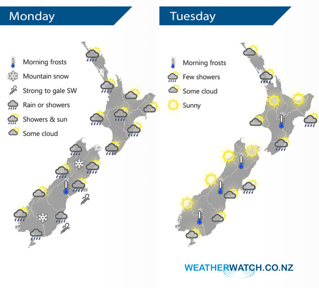
A cold southwesterly airflow lies over the country today however it will start to ease overnight as an anticyclone muscles in from the Tasman Sea. This flow eases further on Tuesday although it may still be fresh about eastern coastal areas in the morning.
Showers for most western parts of the North Island today, a few snow flurries about higher parts of the Central Plateau / Desert Road. Drier about the Hawkes Bay, Gisborne and Bay Of Plenty. Showers for most South Island regions also however mainly dry about Nelson, Marlborough, South Westland and South Canterbury. Some parts of Canterbury will have a frosty start this morning. Snow flurries about the hills / ranges of inland Nelson and Buller to 500m, snow to 400m about Southland and Otago. Snow to 500m about Banks Peninsula from evening.
Mainly sunny and or dry for western parts of the country on Tuesday, quite cold to start though especially for inland areas. The odd shower clears the Auckland region in the afternoon. Morning cloud for Southland and Otago clears then mostly sunny, some cloud at times during the day for Canterbury with showers out on Banks Peninsula clearing during the afternoon. Showers about the Wairarapa and Mahia Peninsula ease during the day.
By Weather Analyst Aaron Wilkinson – WeatherWatch.co.nz
Comments
Latest Video

Frosts, clearer skies coming – severe weather possible this weekend
High pressure lies south of NZ today and that placement encourages a colder south-east wind into the North Island bringing…
Related Articles
Frosts, clearer skies coming – severe weather possible this weekend
High pressure lies south of NZ today and that placement encourages a colder south-east wind into the North Island bringing…

NZ: 8 Day outlook as gales & rain ease, high pressure builds
Damaging wind gusts and heavy rain will continue to affect some parts of the North Island and brushing Marlborough today…

Pockets of hit & miss heavy rain, snow moves northwards
Low pressure continues to slowly move across the upper North Island and for some that will bring the sun out,…


Guest on 17/06/2019 4:50am
if you go from august the 31 2018 to aug the 31 2019 well unless it rains more this winter every season will had been dry which must be un heard off as sept and oct were below average last year in some places