InfoGraphic: The Big Picture for Monday / Tuesday
12/05/2019 7:00pm

> From the WeatherWatch archives
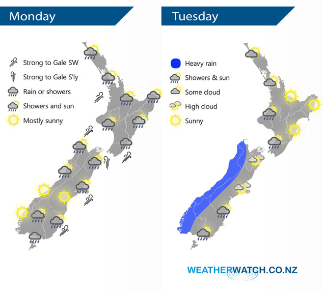
A cold southwesterly airflow lies over New Zealand today bringing wet weather to most, conditions will start to ease from afternoon as a ridge begins to push in. Northwesterlies build on Tuesday then a front moves onto the South Island in the afternoon reaching the lower North Island overnight.
Showers about the upper North Island easing during today, mostly clearing by evening as blustery southwest winds ease and tend more southerly. Morning rain for the lower North Island eases to showers then mostly clearing in the evening. Early rain about the upper South Island clears then sunny areas increase, the odd shower may linger about Nelson / Marlborough till afternoon however. The odd shower continues about Southland / Otago for much of the day, mostly sunny on the West Coast after any morning showers clear.
A settled start for much of the North Island on Tuesday, some cloud builds in the west from afternoon, perhaps a light shower or two Waikato southwards in the west. Mainly sunny weather in the east. Showers for the South Islands West Coast, heavy rain about South Westland slowly moves northwards during the day. Mainly dry in the east then rain / showers moves into Southland around midday, Otago during the afternoon and Canterbury in the evening.
By Weather Analyst Aaron Wilkinson – WeatherWatch.co.nz
Latest Video

NZ: 8 Day outlook as gales & rain ease, high pressure builds
Damaging wind gusts and heavy rain will continue to affect some parts of the North Island and brushing Marlborough today…
Related Articles
NZ: 8 Day outlook as gales & rain ease, high pressure builds
Damaging wind gusts and heavy rain will continue to affect some parts of the North Island and brushing Marlborough today…

Pockets of hit & miss heavy rain, snow moves northwards
Low pressure continues to slowly move across the upper North Island and for some that will bring the sun out,…

Slow go for northern low & southern cold
For the next few days low pressure will crawl over the upper North Island, driving in rain as far south…

