InfoGraphic: The Big Picture for Monday / Tuesday
7/04/2019 7:00pm

> From the WeatherWatch archives
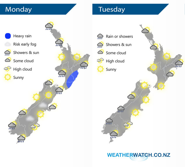
A ridge of high pressure lies over the South Island today meanwhile expect a south to southeasterly airflow for the North Island, easing later in the day. A ridge covers the upper South Island and North Island on Tuesday bringing mainly settled weather, a northerly airflow picks up for the lower South Island.
Wet weather for the eastern North Island today, heavy rain about the Wairarapa eases around midday. Mostly sunny out west however there may be a few morning showers Auckland northwards. Mostly sunny for the South Island with some morning cloud in the northeast, perhaps even an early coastal shower. Risk of a morning fog patchy about Canterbury then breaking away. Dry about the far south till evening when a few showers move into Fiordland and spots of rain spread into Southland.
Mostly sunny for a majority of the North Island on Tuesday, some morning cloud possible in the east, perhaps an early shower for Gisborne. A few clouds drifting in at times from the Tasman into Auckland and Northland. Cloud thickens along the South Island’s West Coast, rain or showers slowly spread north along the coast during the day. Spots of rain possible at times about Southland, mostly sunny elsewhere.
By Weather Analyst Aaron Wilkinson – WeatherWatch.co.nz
Comments
Latest Video

Matariki, the long weekend + the outlook for next week
Wet weather and cloud continues along the eastern side of the country with the heaviest rain now moving into northern…
Related Articles
Matariki, the long weekend + the outlook for next week
Wet weather and cloud continues along the eastern side of the country with the heaviest rain now moving into northern…

More eastern rain, but a drier long weekend coming
Rain continues today along the eastern South Island and lower North Island, coming in from the east with heavy falls….

More heavy rain, snow – but large dry areas, especially as we go into the long weekend
Heavy rain will continue for parts of Canterbury and Marlborough over the next day or two and it will gradually…


LM on 7/04/2019 11:32pm
Always quick to put a ‘shower’ icon over Southland. Northerly flow may increase the chance for showers/drizzle over Fiordland and maybe western Southland at worst. As for the shower icon over Auckland, its looking sunny there today! A bit like your weekend graphic outlook for Sunday that showed Canterbury as sunny and Southland with high cloud on – totally wrong!
WW Forecast Team on 8/04/2019 12:24am
Hi LM, thanks as always for your critical comments about our free service. Southland covers more than just Invercargill – take a look at the past 7 days rainfall and you’ll see why it’s a hard region to forecast for ‘generically’. It’s why we have 10 day hourly forecasts for your specific location – anyone that wants a perfect forecast would surely look beyond one generic nationwide infographic! Ps. Auckland does have some light isolated showers in the western regions today.
Kind regards and thanks for using our free services
Philip Duncan