InfoGraphic: The Big Picture for Monday / Tuesday
10/03/2019 6:27pm

> From the WeatherWatch archives
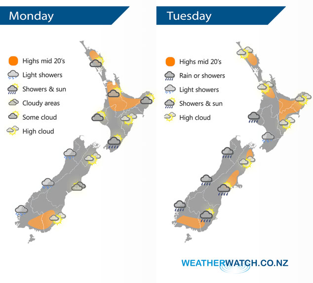
A ridge of high pressure gradually weakens over New Zealand today letting in a northerly airflow. This northerly airflow continues on Tuesday.
Mainly dry for most of the North Island today, expect areas of cloud though. A few showers crop up this afternoon for the Wairarapa. Cloudy for the West Coast of the South Island with a few showers or drizzle patches, morning cloud in the east breaks to some sun although expect plenty of high cloud. While not indicated on the map below a shower or spit may spread into inland Canterbury / Marlborough late afternoon or evening.
Dry for much of the North Island again on Tuesday however from Taranaki through to Wellington expect a few showers especially afternoon onwards. The West Coast of the South Island sees morning rain ease to the odd shower, mainly dry in the east however south of Banks Peninsula through to Otago there may be some morning rain then the risk of a shower late afternoon / evening.
By Weather Analyst Aaron Wilkinson – WeatherWatch.co.nz
Latest Video

NZ: 8 Day outlook as gales & rain ease, high pressure builds
Damaging wind gusts and heavy rain will continue to affect some parts of the North Island and brushing Marlborough today…
Related Articles
NZ: 8 Day outlook as gales & rain ease, high pressure builds
Damaging wind gusts and heavy rain will continue to affect some parts of the North Island and brushing Marlborough today…

Pockets of hit & miss heavy rain, snow moves northwards
Low pressure continues to slowly move across the upper North Island and for some that will bring the sun out,…

Slow go for northern low & southern cold
For the next few days low pressure will crawl over the upper North Island, driving in rain as far south…

