InfoGraphic: The Big Picture for Monday / Tuesday
4/11/2018 6:00pm

> From the WeatherWatch archives
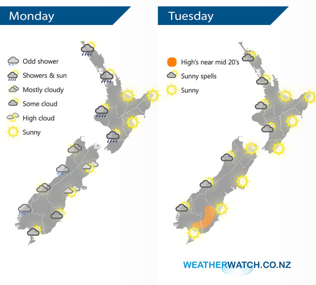
A fairly typical spring west to southwesterly airflow lies over New Zealand today, it will have eased a bit compared to wind strengths that were over the country yesterday. A large anticyclone centred just north of the North Island casts a ridge of high pressure over New Zealand on Tuesday bringing mainly settled conditions.
A shower or two for the western North Island today, more so this morning but the odd straggler may continue through this afternoon / evening. Winds breezy from the west or southwest. Mostly sunny about the Bay Of Plenty, along the east coast and for Wellington. Mostly cloudy for the West Coast of the South Island with the odd shower, breezy southwesterlies. Mostly sunny for Nelson down through to Canterbury in the east, westerly quarter winds tend north to northeast this afternoon. Sunny spells about Otago, skies may be a little cloudier for Southland with any showers this morning clearing away.
Sunny spells for the western side of the country on Tuesday, sunny in the east. Winds mostly from the westerly quarter, afternoon east to northeasterly winds along the east coast.
By Weather Analyst Aaron Wilkinson – WeatherWatch.co.nz
Latest Video

Matariki, the long weekend + the outlook for next week
Wet weather and cloud continues along the eastern side of the country with the heaviest rain now moving into northern…
Related Articles
Matariki, the long weekend + the outlook for next week
Wet weather and cloud continues along the eastern side of the country with the heaviest rain now moving into northern…

More eastern rain, but a drier long weekend coming
Rain continues today along the eastern South Island and lower North Island, coming in from the east with heavy falls….

More heavy rain, snow – but large dry areas, especially as we go into the long weekend
Heavy rain will continue for parts of Canterbury and Marlborough over the next day or two and it will gradually…

