InfoGraphic: The Big Picture for Monday / Tuesday
28/10/2018 6:00pm

> From the WeatherWatch archives
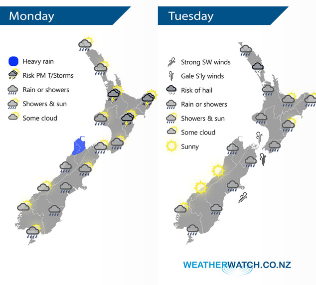
A large area of low pressure moves over New Zealand today bringing mainly unsettled weather. A cold southwesterly airflow lies over New Zealand on Tuesday as this low passes out to the east.
Rain or showers in the west of the North Island spreading eastwards this afternoon, showers may become heavy this afternoon with thunderstorms then easing later on. Winds from the northerly quarter, tending to the south about the lower North Island this afternoon. Rain or showers for much of the South Island today, some coastal areas may stay fairly dry especially the West Coast south of about Hokitika. Rain becomes widespread along the east coast later in the evening / overnight.
Showers for the western North Island on Tuesday, turning to rain in the afternoon Taranaki southwards then easing at night. Showers may be heavy with hail at times Auckland northwards. Rain about Wairarapa spreads northwards during the afternoon. Southerly winds rising to gale through Cook Strait from afternoon. Rain for the eastern South Island easing to showers in the afternoon, clearing later in the evening / overnight for most then watch for frosts around dawn on Wednesday morning. Mostly sunny for the West Coast during the day, a few showers for Buller however.
By Weather Analyst Aaron Wilkinson – WeatherWatch.co.nz
Latest Video

Matariki, the long weekend + the outlook for next week
Wet weather and cloud continues along the eastern side of the country with the heaviest rain now moving into northern…
Related Articles
Matariki, the long weekend + the outlook for next week
Wet weather and cloud continues along the eastern side of the country with the heaviest rain now moving into northern…

More eastern rain, but a drier long weekend coming
Rain continues today along the eastern South Island and lower North Island, coming in from the east with heavy falls….

More heavy rain, snow – but large dry areas, especially as we go into the long weekend
Heavy rain will continue for parts of Canterbury and Marlborough over the next day or two and it will gradually…

