InfoGraphic: The Big Picture for Monday / Tuesday
30/09/2018 6:00pm

> From the WeatherWatch archives
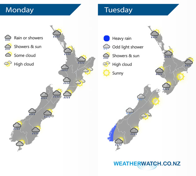
A front moves very slowly northwards over the North Island today, meanwhile an area of low pressure passes over the South Island moving west to east. A southwesterly airflow lies over New Zealand on Tuesday, a front clears the upper North Island in the morning meanwhile a cold front moves onto the lower South Island in the morning.
A front brings some rain to the lower western North Island, especially Taranaki then weakening and moving northwards during the day. Mainly dry weather along the east coast with some high cloud, a few spots of rain spread into Wairarapa at times. Most regions around the South Island will experience rain or showers at some point today, after early morning rain Nelson and Marlborough are mainly dry. Southland has a mainly dry day too.
Morning rain clears most of the upper North Island on Tuesday then sunny areas develop, showers may hang around for Northland till evening however. A dry day for the east coast however Gisborne has morning rain then clearing, a few showers at times in the west Taranaki southwards especially morning. Mostly cloudy for the West Coast of the South Island, chance of a shower and some heavy rain moves into Fiordland for a time. Mainly dry in the east with some developing high cloud, rain moves into Southland during the morning then moving northwards in the form of showers reaching Canterbury in the evening.
By Weather Analyst Aaron Wilkinson – WeatherWatch.co.nz
Latest Video

NZ: 8 Day outlook as gales & rain ease, high pressure builds
Damaging wind gusts and heavy rain will continue to affect some parts of the North Island and brushing Marlborough today…
Related Articles
NZ: 8 Day outlook as gales & rain ease, high pressure builds
Damaging wind gusts and heavy rain will continue to affect some parts of the North Island and brushing Marlborough today…

Pockets of hit & miss heavy rain, snow moves northwards
Low pressure continues to slowly move across the upper North Island and for some that will bring the sun out,…

Slow go for northern low & southern cold
For the next few days low pressure will crawl over the upper North Island, driving in rain as far south…

