InfoGraphic: The Big Picture for Monday / Tuesday
8/07/2018 7:00pm

> From the WeatherWatch archives
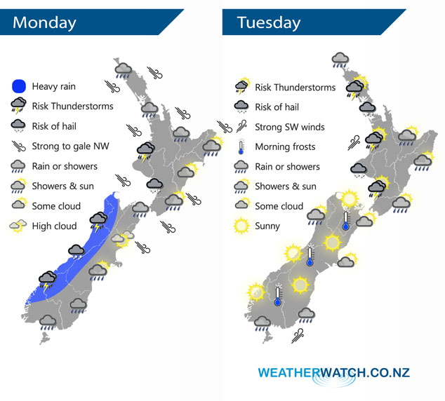
An unsettled westerly quarter airflow brings wet weather in the west today with drier conditions out east, however a small low sitting east of the South Island encourages a southwest change to push northwards bringing rain or showers through into Canterbury by evening. New Zealand lies under a southwesterly airflow on Tuesday, potentially unstable in the morning for the North Island especially in the west.
Quite unsettled today with a strong northwesterly airflow turning southwest about the lower South Island during today. Expect wet weather for much of the North Island however Gisborne down through to the Wairarapa just sees spill over rain at times coming in from the west. Thunderstorms and some hail possible in the west also, mainly Taranaki southwards but perhaps further north near the coast later this evening. Heavy rain and a chance of thunderstorms / hail for the west of the South Island this morning then easing from afternoon, rain or showers developing this morning for Southland / Otago and southern parts of Canterbury then moving northwards in the evening.
Still quite unstable for the western North Island on Tuesday morning, gradually easing from afternoon. A few showers affect the east coast with a southwest change. The South Island starts to clear up with a frosty start expected for many inland areas. A few showers affect Southland and coastal Otago during the day however.
By Weather Analyst Aaron Wilkinson – WeatherWatch.co.nz
Latest Video

NZ: 8 Day outlook as gales & rain ease, high pressure builds
Damaging wind gusts and heavy rain will continue to affect some parts of the North Island and brushing Marlborough today…
Related Articles
NZ: 8 Day outlook as gales & rain ease, high pressure builds
Damaging wind gusts and heavy rain will continue to affect some parts of the North Island and brushing Marlborough today…

Pockets of hit & miss heavy rain, snow moves northwards
Low pressure continues to slowly move across the upper North Island and for some that will bring the sun out,…

Slow go for northern low & southern cold
For the next few days low pressure will crawl over the upper North Island, driving in rain as far south…

