InfoGraphic: The Big Picture for Monday / Tuesday
13/05/2018 7:46pm

> From the WeatherWatch archives
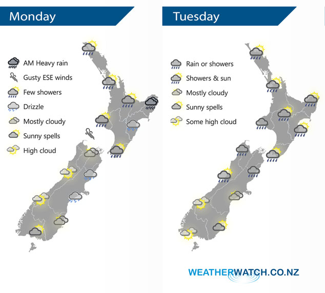
A low sits in the Tasman Sea today drawing in a southeasterly airflow over most of New Zealand although the upper North Island has a northerly airflow. Northeasterlies for much of the country on Tuesday with the Tasman Sea low moving closer to the western side of the South Island later in the day.
While shower icons cover much of the North Island today a large portion of the day will be fairly dry, showers are most likely later this afternoon / evening. There will be some morning rain about East Cape / Gisborne with heavy falls then easing this afternoon. Mostly cloudy for the east of the South Island, some drizzle possible. The West Coast has mostly sunny weather, perhaps a touch of high cloud.
A mix of showers and dry spells for most of the North Island on Tuesday, rain moves through Taranaki at times. Some rain or showers for the upper South Island then progressively getting drier the further south you go. Rain may become heavy about the northwest Nelson ranges later in the day.
By Weather Analyst Aaron Wilkinson – WeatherWatch.co.nz
Latest Video

Wintry weather coming: Snow, rain, wind & sunshine
A cold front is moving into NZ from Friday to Sunday with low pressure developing west of NZ and then…
Related Articles
Wintry weather coming: Snow, rain, wind & sunshine
A cold front is moving into NZ from Friday to Sunday with low pressure developing west of NZ and then…

ClimateWatch: JULY outlook & what El Niño means for NZ
El Niño is officially here and still getting stronger in the months ahead, but it’s harder to notice its effects…

Low pressure heading to NZ this weekend & into next week
Many regions have settled weather at the moment with frosts as far north as Auckland this morning, but still some…

