InfoGraphic: The Big Picture for Friday / Saturday
7/11/2019 6:00pm

> From the WeatherWatch archives
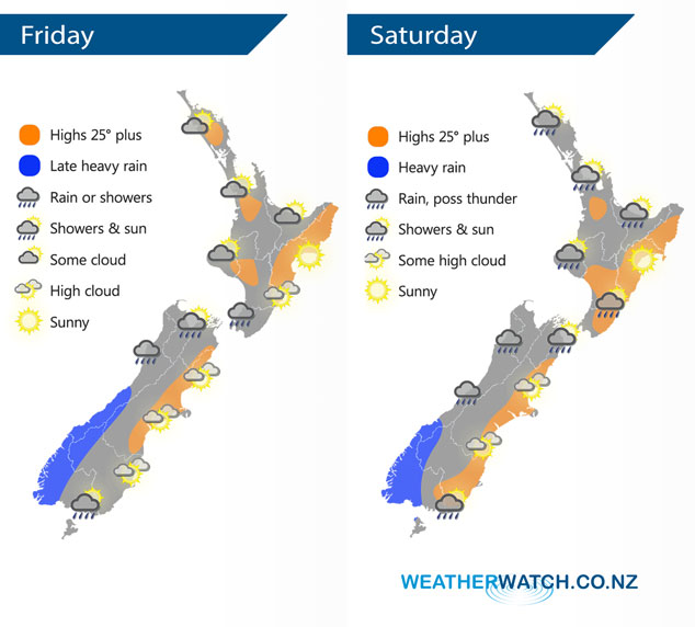
A north to northwesterly airflow lies over New Zealand today, a front in the west weakens this morning. Northerlies continue on Saturday with a front lying across the far south of the South Island.
Sunny spells and the odd isolated shower possible for the upper North Island on Friday, mainly dry overall. A few showers in the southwest (Kapiti and perhaps Taranaki at times). Mainly sunny in the east, some high cloud. Morning heavy rain for the West Coast of the South Island then easing to showers, rain becomes heavy again later in the evening. Sunny areas and some high cloud along the east coast. Southland sees any early rain clear then sunny areas develop, overnight further rain moves in.
Showers and sunny spells for the northern and western North Island on Saturday, mainly sunny in the east although Wairarapa could see a few spots of rain in the afternoon spreading from the west. Expect rain for the West Coast, perhaps the odd rumble of thunder, heavy rain about Fiordland spreads northwards in the evening. Showers or rain about Nelson spreads into Marlborough from afternoon. Sunny areas and some high cloud in the east. Some rain about Southland (mainly morning), spreading into Central Otago in the evening (heavy) then coastal Otago overnight.
By Weather Analyst Aaron Wilkinson – WeatherWatch.co.nz
Latest Video

Cold weekend, frosts return with high pressure, then a low late next week
The subantarctic airflow spreads over NZ today/tonight and into Saturday, dropping temperatures nationwide. Snow flurries are possible today to lower…
Related Articles
Cold weekend, frosts return with high pressure, then a low late next week
The subantarctic airflow spreads over NZ today/tonight and into Saturday, dropping temperatures nationwide. Snow flurries are possible today to lower…

Wintry burst of weather: Snow, squally showers then sunshine & frosts
A polar change (another one!) arrives on Friday for the South Island and goes nationwide on Saturday, leaving NZ under…

Antarctic southerly for parts of NZ Fri & Sat
For the first time this year a southerly from off Antarctica is heading towards the South Island, followed by more…

