InfoGraphic: The Big Picture for Friday / Saturday
26/09/2019 7:55pm

> From the WeatherWatch archives
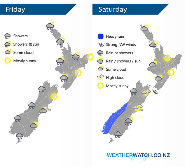
A west to southwesterly airflow lies over the country today, tending more westerly on Saturday.
Occasional showers for the western North Island today, easing this evening with long dry spells developing. Showers develop this morning about Wairarapa then a few push northwards into Hawkes Bay and Gisborne during the afternoon. A generally showery day for Southland and along the West Coast of the South Island, Otago has morning cloud with the risk of a shower then sunny spells develop. Mostly sunny about Canterbury and Marlborough / Nelson after any morning cloud breaks.
Sunny areas and some cloud for the western North Island on Saturday, mainly dry but the risk of a light shower or two at times is there. Mainly sunny conditions for eastern regions. For the South Island we have rain for the West Coast, gradually becoming heavy as the day moves along. Generally drier in the east with some high cloud, a few spits or showers move into Southland late afternoon then reaching Otago overnight.
By Weather Analyst Aaron Wilkinson – WeatherWatch.co.nz
Latest Video

Matariki, the long weekend + the outlook for next week
Wet weather and cloud continues along the eastern side of the country with the heaviest rain now moving into northern…
Related Articles
Matariki, the long weekend + the outlook for next week
Wet weather and cloud continues along the eastern side of the country with the heaviest rain now moving into northern…

More eastern rain, but a drier long weekend coming
Rain continues today along the eastern South Island and lower North Island, coming in from the east with heavy falls….

More heavy rain, snow – but large dry areas, especially as we go into the long weekend
Heavy rain will continue for parts of Canterbury and Marlborough over the next day or two and it will gradually…

