InfoGraphic: The Big Picture for Friday / Saturday
4/07/2019 7:00pm

> From the WeatherWatch archives
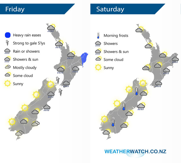
A cold southerly airflow covers the country today, running between a large high to the west of New Zealand and a low to the east. This southerly airflow eases later on Saturday as the high starts to push in more.
Rain or showers for the eastern North Island today, heavy about Gisborne at first then easing. Out west conditions are a bit drier however there may be a few isolated showers about. Sunny for the South Islands West Coast, fairly dry in the east however the odd shower moves into Mid and North Canterbury during the day.
A few showers continue to push into the North Islands east coast on Saturday, a mix of sun and cloud out west. Another sunny day for the South Islands West Coast and Nelson, some cloud for most in the east with a few showers out on Banks Peninsula. There is there risk of shower or two about Southland and coastal Otago through till evening otherwise mainly dry.
By Weather Analyst Aaron Wilkinson – WeatherWatch.co.nz
Latest Video

Frosts, clearer skies coming – severe weather possible this weekend
High pressure lies south of NZ today and that placement encourages a colder south-east wind into the North Island bringing…
Related Articles
Frosts, clearer skies coming – severe weather possible this weekend
High pressure lies south of NZ today and that placement encourages a colder south-east wind into the North Island bringing…

NZ: 8 Day outlook as gales & rain ease, high pressure builds
Damaging wind gusts and heavy rain will continue to affect some parts of the North Island and brushing Marlborough today…

Pockets of hit & miss heavy rain, snow moves northwards
Low pressure continues to slowly move across the upper North Island and for some that will bring the sun out,…

