InfoGraphic: The Big Picture for Friday / Saturday
6/06/2019 7:43pm

> From the WeatherWatch archives
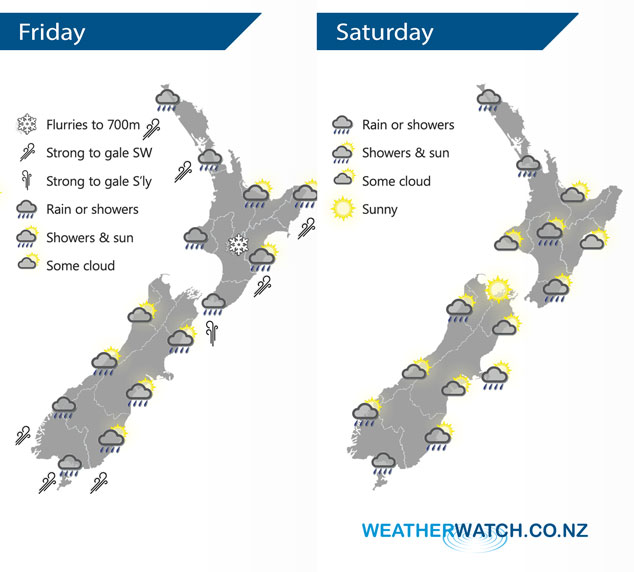
A cold southwesterly airflow lies over the country today and on Saturday.
Heavy showers ease about the upper North Island this morning, some sun may break through from afternoon otherwise staying fairly cloudy, winds strong from the southwest with offshore gales. Showers about the lower western North Island clear in the evening. Any early spots of rain clear along the east coast then showers move in again late afternoon / early evening for a time, winds fresh from the southwest. Showers and strong to gale southerly winds for Wellington ease during the day. Morning showers clear the South Island’s east coast, mainly sunny in the west then cloud and a few showers develop later in the evening. Showers ease during the day about Southland, strong west to southwest winds after midday.
Showers affect most North Island regions on Saturday, the Bay Of Plenty may stay mainly dry. Dry in the morning for Hawkes Bay and Gisborne then a few showers move through in the afternoon and evening as southwesterlies strengthen. Morning showers for the South Island’s West Coast then sun increasing with cool southwesterly winds, Nelson and Marlborough have a mainly dry day. Mainly dry for Canterbury however a few coastal showers can be expected for a time early afternoon as southwesterlies freshen. Showers about Southland and Otago ease during the day, clearing in the evening.
By Weather Analyst Aaron Wilkinson – WeatherWatch.co.nz
Latest Video

NZ: 8 Day outlook as gales & rain ease, high pressure builds
Damaging wind gusts and heavy rain will continue to affect some parts of the North Island and brushing Marlborough today…
Related Articles
NZ: 8 Day outlook as gales & rain ease, high pressure builds
Damaging wind gusts and heavy rain will continue to affect some parts of the North Island and brushing Marlborough today…

Pockets of hit & miss heavy rain, snow moves northwards
Low pressure continues to slowly move across the upper North Island and for some that will bring the sun out,…

Slow go for northern low & southern cold
For the next few days low pressure will crawl over the upper North Island, driving in rain as far south…

