InfoGraphic: The Big Picture for Friday / Saturday
31/01/2019 6:00pm

> From the WeatherWatch archives
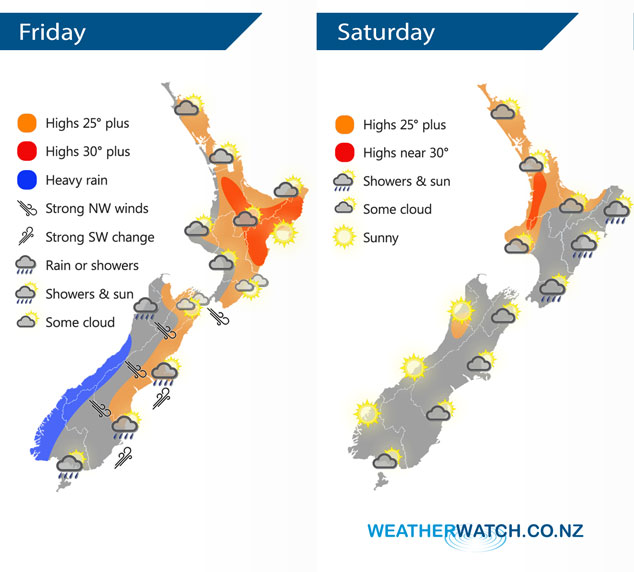
A cold front pushes northwards over the South Island today, weakening as it goes. A ridge lies over the North Island with the aforementioned front arriving about the lower North Island overnight. A ridge of high pressure pushes in over the South Island on Saturday meanwhile a southeasterly airflow lies over the North Island.
A northwesterly airflow lies over the North Island today, expect some cloud in the west with sunnier conditions out east. There may be a light shower or two this morning for Taranaki and Kapiti then overnight further rain or showers moves in. Rain pushes northwards along the West Coast of the South Island, heavy about South Westland but easing as it moves northwards. Gusty northwesterlies in the east but a cool southwest change moves in bringing rain or showers to Southland and Otago in the morning then Canterbury in the afternoon.
Showers for the eastern North Island on Saturday, drier out west however a late afternoon / evening shower is possible from Bay Of Plenty through to Northland. The South Island has mostly sunny weather however there may be some early morning cloud in the east, perhaps an early shower for Southland also then clearing.
By Weather Analyst Aaron Wilkinson – WeatherWatch.co.nz
Latest Video

Matariki, the long weekend + the outlook for next week
Wet weather and cloud continues along the eastern side of the country with the heaviest rain now moving into northern…
Related Articles
Matariki, the long weekend + the outlook for next week
Wet weather and cloud continues along the eastern side of the country with the heaviest rain now moving into northern…

More eastern rain, but a drier long weekend coming
Rain continues today along the eastern South Island and lower North Island, coming in from the east with heavy falls….

More heavy rain, snow – but large dry areas, especially as we go into the long weekend
Heavy rain will continue for parts of Canterbury and Marlborough over the next day or two and it will gradually…

