InfoGraphic: The Big Picture for Friday / Saturday
13/12/2018 6:00pm

> From the WeatherWatch archives
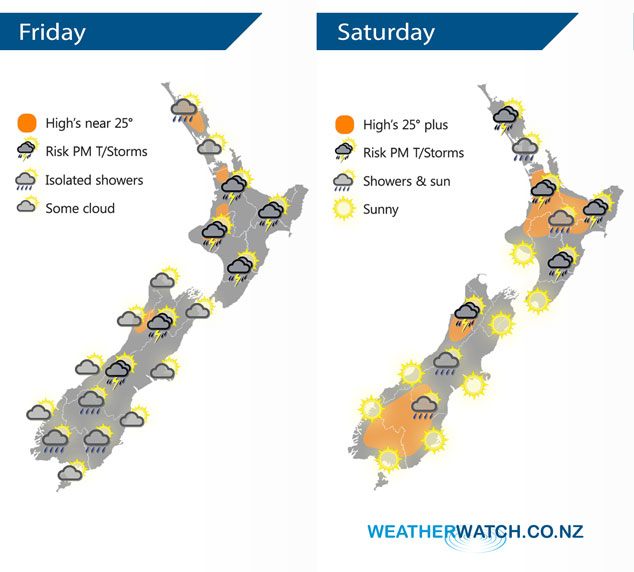
A large high pressure system lies to the east of New Zealand today, slowly pushing a humid northeasterly airflow over the country. Anticyclonic conditions for most of New Zealand on Saturday mean the weather is starting to become quite settled and areas of sun are finally breaking through for many. However, some residual surface moisture and afternoon heating plus relatively cold air aloft leads to a chance of thunderstorms in the afternoon for some inland areas.
A fairly dry morning for a majority of New Zealand today, there may be a shower or two about Nelson / Marlborough, Wairarapa and Taranaki. Then this afternoon showers developing about many inland areas, some becoming heavy with thunderstorms then easing later in the evening. Light winds for most then afternoon sea breezes.
A few isolated showers about the upper North Island on Saturday, becoming heavy with some thunder in the afternoon for inland areas then easing later in the evening. The lower North Island has a mostly sunny day, however, cloud builds about the ranges from Wairarapa through to Gisborne in the afternoon bringing showers. Showers possibly heavy with thunderstorms then easing later in the evening. Mostly sunny for the South Island however a few isolated showers crop up about inland areas in the afternoon, a chance of thunder for Buller.
By Weather Analyst Aaron Wilkinson – WeatherWatch.co.nz
Latest Video

Matariki, the long weekend + the outlook for next week
Wet weather and cloud continues along the eastern side of the country with the heaviest rain now moving into northern…
Related Articles
Matariki, the long weekend + the outlook for next week
Wet weather and cloud continues along the eastern side of the country with the heaviest rain now moving into northern…

More eastern rain, but a drier long weekend coming
Rain continues today along the eastern South Island and lower North Island, coming in from the east with heavy falls….

More heavy rain, snow – but large dry areas, especially as we go into the long weekend
Heavy rain will continue for parts of Canterbury and Marlborough over the next day or two and it will gradually…

