InfoGraphic: The Big Picture for Friday / Saturday
30/08/2018 7:00pm

> From the WeatherWatch archives
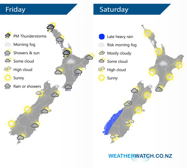
A low pressure system lies over New Zealand today with two centres either side of the country. A weak ridge lies over New Zealand on Saturday bringing mainly settled weather, meanwhile a front approaches from the west in the Tasman Sea.
Mainly dry for the upper North Island this morning, perhaps some fog to start then afternoon isolated showers develop with a possibility of thunderstorms. Rain or showers about Wellington and the Wairarapa spreading into Hawkes Bay and Gisborne during the afternoon / evening. The South Island is mainly dry although cloud thickening in the east from afternoon could bring a light shower or two, sunnier conditions out west.
Much of the country is mainly settled and sunny on Saturday. A front approaching from the west in the Tasman Sea brings late evening / overnight heavy rain to South Westland.
By Weather Analyst Aaron Wilkinson – WeatherWatch.co.nz
Latest Video

Matariki, the long weekend + the outlook for next week
Wet weather and cloud continues along the eastern side of the country with the heaviest rain now moving into northern…
Related Articles
Matariki, the long weekend + the outlook for next week
Wet weather and cloud continues along the eastern side of the country with the heaviest rain now moving into northern…

More eastern rain, but a drier long weekend coming
Rain continues today along the eastern South Island and lower North Island, coming in from the east with heavy falls….

More heavy rain, snow – but large dry areas, especially as we go into the long weekend
Heavy rain will continue for parts of Canterbury and Marlborough over the next day or two and it will gradually…

