InfoGraphic: The Big Picture for Friday / Saturday
19/07/2018 7:00pm

> From the WeatherWatch archives
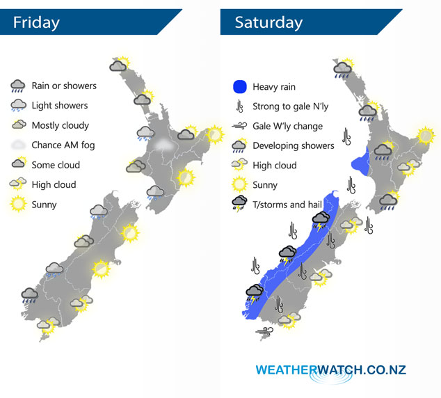
A westerly airflow lies over the North Island today while Northerlies develop further south. A front pushes northwards over the South Island during Saturday, reaching the western North Island later in the evening. Expect strong northerly winds ahead of this front then changing westerly in behind.
Some cloud for the western North Island today, perhaps a light shower or two also. Sunnier conditions out east. A similar story for the South Island however showers or rain will be a bit more persistent about Fiordland during the day.
Heavy rain for the West Coast of the South Island spreads into Taranaki later in the evening, thunderstorms and hail are possible also mainly from afternoon for the West Coast. Expect strong northerly winds for many parts of the South Island and lower North Island during the day, changing westerly during the afternoon and evening.
By Weather Analyst Aaron Wilkinson – WeatherWatch.co.nz
Latest Video

Wintry weather coming: Snow, rain, wind & sunshine
A cold front is moving into NZ from Friday to Sunday with low pressure developing west of NZ and then…
Related Articles

Polar airflow + northern low = pockets of heavy rain & snow
A colder change is coming – and so too is a large low which will develop and grow over northern…
Wintry weather coming: Snow, rain, wind & sunshine
A cold front is moving into NZ from Friday to Sunday with low pressure developing west of NZ and then…

ClimateWatch: JULY outlook & what El Niño means for NZ
El Niño is officially here and still getting stronger in the months ahead, but it’s harder to notice its effects…

