Heightened risk for Flooding & Slips this weekend around Gisborne and East Cape (+3 Maps)
2/08/2018 9:01pm

> From the WeatherWatch archives
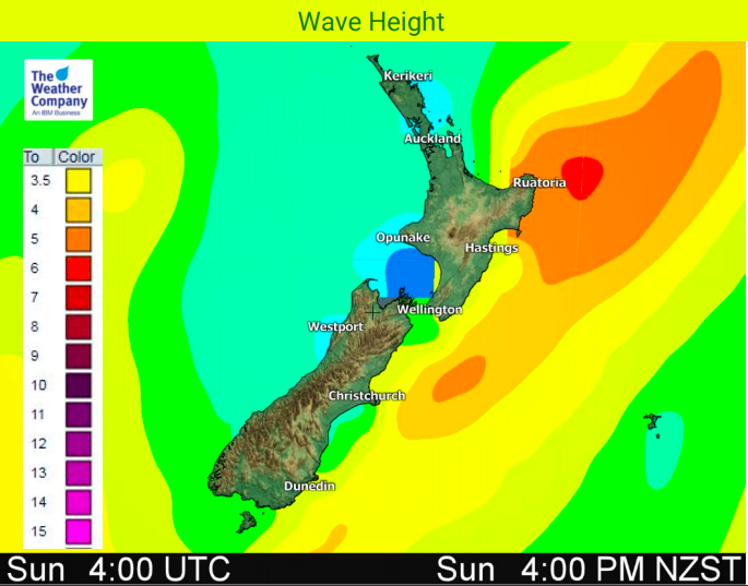
A narrow area of rain is today crossing the North Island and will stall over the East Cape/Gisborne region, then intensify later on Saturday and early Sunday thanks to a sub-tropical system nearby.
Rain may fall for the next three days in generally the same area with totals exceeding 200mm around the Raukumara Forest Park / Gisborne Ranges area with some spillover into the waterways of eastern Bay of Plenty too.
WeatherWatch.co.nz says on top of the heavy rain, strong nor’easters and dangerous beach conditions will also prevail in the east. Slips, power cuts and road closures are all very possible in the north eastern corner of the North Island this weekend and WeatherWatch.co.nz advises travellers to be prepared for problems and for locals to have emergency kits with enough food and drinking water for three days per person in case some people are cut off for a few days.
Next week rain starts to ease as westerlies kick back in again, making for drier weather in the east.


– WeatherWatch.co.nz
Latest Video

Cold weekend, frosts return with high pressure, then a low late next week
The subantarctic airflow spreads over NZ today/tonight and into Saturday, dropping temperatures nationwide. Snow flurries are possible today to lower…
Related Articles
Cold weekend, frosts return with high pressure, then a low late next week
The subantarctic airflow spreads over NZ today/tonight and into Saturday, dropping temperatures nationwide. Snow flurries are possible today to lower…

Wintry burst of weather: Snow, squally showers then sunshine & frosts
A polar change (another one!) arrives on Friday for the South Island and goes nationwide on Saturday, leaving NZ under…

Antarctic southerly for parts of NZ Fri & Sat
For the first time this year a southerly from off Antarctica is heading towards the South Island, followed by more…

