Heavy rain returning this weekend, colder southerlies arrive Saturday night/Sunday (+6 Maps)
5/11/2020 9:19pm

> From the WeatherWatch archives
Temperatures: A cooler southerly change has spread up the South Island and into the lower North Island but as early as this evening milder winds may be returning for some.
Saturday sees a fairly mild day across NZ – although again Canterbury will have below average temperatures.
But it’s Saturday night and across Sunday that will see the next surge of southerlies heading north. Saturday night will be below average across a large portion of the South Island.
The North Island is mild right through the weekend although Sunday will feel a cool down, but Monday is when temperatures drop further.


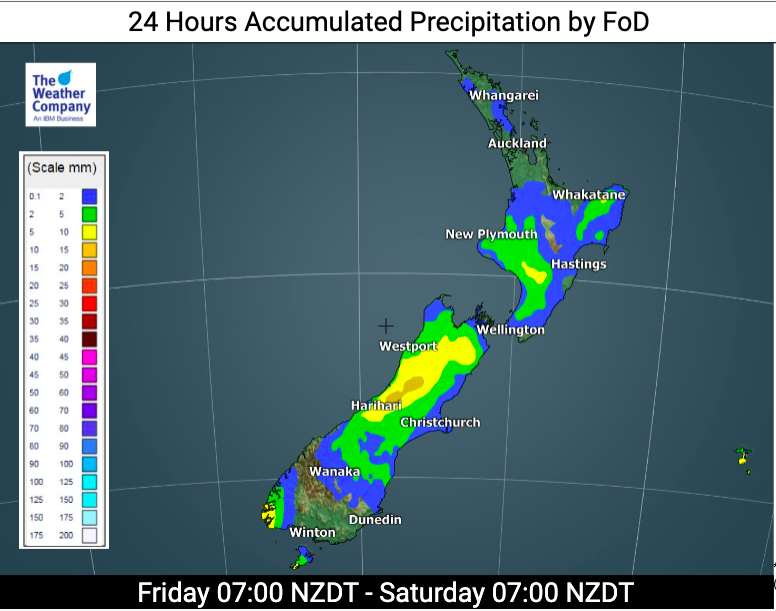
Rain: A low is also developing in the Tasman Sea on Saturday and will move over New Zealand this weekend, coming in on Saturday night/Sunday morning and likely triggering another area of low pressure into Sunday, Monday and maybe even Tuesday. Good news for the North Island regions needing rain.
Rain today (Friday) isn’t too heavy, a few light showers here and there for the most part. But on Saturday night and into Sunday morning heavy falls are expected through central NZ (upper South Island and lower North Island)
Wellington and Christchurch are both in the mix for heavy falls along with Taranaki and Bay of Plenty. Elsewhere a few brief heavy downpours are possible and even an isolated thunderstorm or two possible on Saturday PM in the very upper North Island (although not locked in).
As always, to make sense of these maps for your specific location this weekend, please see the HOURLY forecast data at both www.WeatherWatch.co.nz and www.RuralWeather.co.nz
Latest Video

Slow moving low to track over northern NZ
A low pressure zone will slowly cross the North Island over the coming days, bringing hit and miss pockets of…
Related Articles
Slow moving low to track over northern NZ
A low pressure zone will slowly cross the North Island over the coming days, bringing hit and miss pockets of…

NI low pressure, SI polar change
Low pressure will move over the upper North Island this week, bringing hit and miss pockets of heavier rain into…

Rain & showers this weekend, colder change next week
Some places will warm up over the next day or so as a nor’wester out of Australia moves across NZ,…

