Frost or no frost, that is the question tonight/Saturday AM (+6 Maps)
16/03/2018 12:00am

> From the WeatherWatch archives
Updated 1pm Friday — A cold change today will see southerlies blow across the South Island and temperatures dropping significantly behind it. It’s yet another example of Autumn’s weather pattern being here – we’re seeing a mix of warm to hot days and then some brief cold changes.
Friday sees wind and showers across the South Island but by Saturday a large high will move in and calm things down – and this means a cold night is on the way on Friday night/Saturday morning with the high ‘locking in’ the brief cold snap.
Air temperatures indicate we’re on the cusp of frosts for the first time in 2018 with overnight lows dropping to just 1 or 2 degrees in Southland and some parts of Otago and the high country of Canterbury. Air temperatures are measured at body height and frosts occur at feet level where the air can be a couple of degrees lower than the forecast overnight low.
Generally we’re seeing a lot of 3s and 4s Celsius across inland parts of the South Island, but a few 1s and 2s are sneaking in there too. So watch out for a very light but possible first frost of 2018 early on Saturday.
It’s very short lived – by Sunday we’re back to warmer westerlies thanks to a giant Southern Ocean storm (see our news feed for more details on that).
Weather Highlights
- A trough passes through New Zealand today while weakening.
- High pressure covers the South Island tonight, although the trough produces a few showers in the North Island.
- Saturday, the high pressure becomes stronger and slowly shifts eastward over the South Island.
- Humid air flows into the upper eastern North island brings showers to some areas, but heavy rain may not occur.
- Lovely weather across the South Island and the south and western parts of the North Island on Saturday.
- As for temperatures, it is warm during the day time in many parts of both islands today and tomorrow.
- Maximum temperatures for Friday are higher than for Saturday, but more sunshine is expected tomorrow.
- Minimum temperatures are lower than average tonight for many places.
- It will be below 4C in some areas of the South Island with calm winds, so frost may be possible tonight inland.
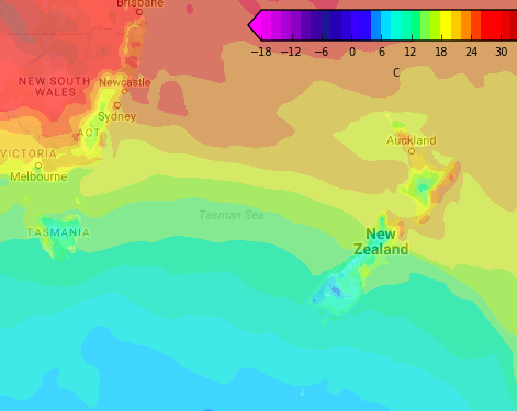 – 1pm Temperature map for Friday shows the cold front moving up the South Island and approaching Cook Strait.
 – 7am Temperature map for Saturday shows the inland South Island in the low single digits with frosts possible inland as far north as Canterbury and in northern Southland (which appears coldest).
– Temperature maps by Weathermap.co.nz

– WeatherWatch.co.nz
Latest Video

Cold weekend, frosts return with high pressure, then a low late next week
The subantarctic airflow spreads over NZ today/tonight and into Saturday, dropping temperatures nationwide. Snow flurries are possible today to lower…
Related Articles
Cold weekend, frosts return with high pressure, then a low late next week
The subantarctic airflow spreads over NZ today/tonight and into Saturday, dropping temperatures nationwide. Snow flurries are possible today to lower…

Wintry burst of weather: Snow, squally showers then sunshine & frosts
A polar change (another one!) arrives on Friday for the South Island and goes nationwide on Saturday, leaving NZ under…

Antarctic southerly for parts of NZ Fri & Sat
For the first time this year a southerly from off Antarctica is heading towards the South Island, followed by more…

