Friday’s national forecast – High pressure, hot nor’westers for some & mostly dry (+5 Maps)
12/11/2020 3:00pm

> From the WeatherWatch archives
A large high is dominating New Zealand and brings a mild, dry, end to the week for most places.
Cloud will line up along the West Coast with perhaps a drizzle patch or two, or a light shower, in the mix. Otherwise a dry day.
On the eastern side of New Zealand (both the North and South Islands) the daytime highs will be in the mid to late 20s with some places inland making it to the 30 degree mark.
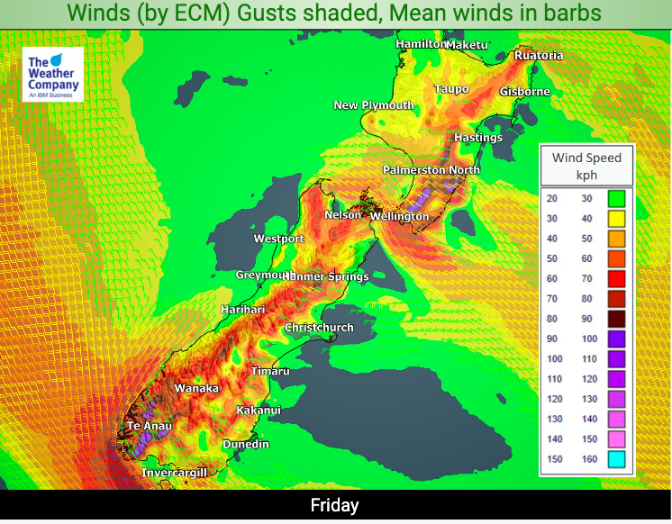
Nor’west winds will be brisk to strong through Wellington and Cook Strait and also through a few South Island mountain valleys. The ranges in the lower South Island may also get gusts to 100km/h.
The upper North Island remains under the high pressure belt, bringing light variable winds – or a light west to north west breeze.
Here are the regional forecasts for Friday
Northland, Auckland, Waikato & Bay Of Plenty
Light variable winds under high pressure with a mix of sun and cloud.
Highs: 20 – 24
Western North Island (including Central North Island)
A mix of sun and cloud with west to north west winds developing.
Highs: 16 – 22
Eastern North Island
Varying winds with a north to north east flow around Gisborne and northern Hawke’s Bay while a west to north west flow kicks in further south. A sunny day and hot through northern Hawke’s Bay and inland Gisborne.
Highs: 20 – 28
Wellington
A little cloudy at times with brisk north to north west winds, possibly gale in more exposed areas. High: 17
Marlborough & Nelson
Northerlies and mostly sunny.
Highs: 21 – 25
Canterbury
A cool start but a mostly sunny day on the way, with north to north west winds pushing temperatures up inland into the late 20s, maybe even 30.
Highs: 20 – 30
West Coast
A mix of sun and cloud. Nor’West breezes.
Highs: 16 – 22
Southland & Otago
A bit cloudy and slightly cooler in coastal areas. Northerly quarter winds, leaning Nor’West for many. Hottest in Central Otago where again you’re pushing closer to 30 degrees.
Highs: 18-28
THE MAPS


Comments
Before you add a new comment, take note this story was published on 12 Nov 2020.


Add new comment