Damaging gales blast parts of South Island, restless night for many (+Photos 2)
4/10/2015 10:55am

> From the WeatherWatch archives
Updated 11:55pm — Damaging gales continue to hit parts of the South Island overnight tonight with Dunedin facing a very windy night, with possibly a surge in severe gales as the south west change moves through between midnight and dawn. This change happens over the early hours of Monday morning and may see damaging gusts over 100km/h in the city, suburbs and on Otago Peninsula. Winds should start to ease back late on Monday morning.
While the tops of some mountains and ranges have been recording wind gusts up to and over 170km/h, more populated areas have been spared the full brunt, as was forecast. However Dunedin was slammed by damaging gales late on Sunday afternoon with gales increasing again later in the evening.
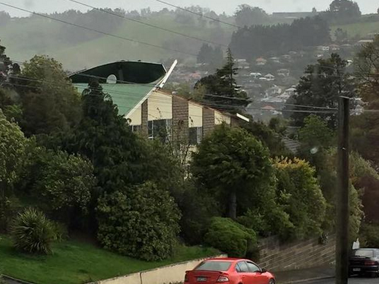
Image / A roof in the Dunedin suburb of Abbotsford partially lifting on Sunday PM / Photo sent into @WeatherWatchNZ on Twitter by Adam Walker.
Winds will peak overnight – for many it will be a windy, restless, night.
The winds lifted temperatures well into the 20s today and later this week more warm to hot weather is expected – not a good sign for some farmers so early into spring and more evidence El Nino’s pattern is perhaps setting in to New Zealand now.
 Wild winds whip up dust near Wanaka today – photo by @WanakaSun on Twitter sent into @WeatherWatchNZ – view the animated version via the Wanaka Sun’s Twitter account.
The strongest gusts are being shaped by the mountains and valleys – meaning the zones of wind with damage potential is a continually moving, shifting, changing, thing – and WeatherWatch.co.nz supports the weather warnings issued by state forecaster MetService today.
Most main centres should be spared too many serious issues but damaging gusts are possible tonight – especially inland and amongst the mountains. However the wind flow will turn south west overnight.
The 170km/h gust today was recorded on a very exposed hill in Southland this morning, Mid Dome.
====
How are conditions where you are tonight? Let us know by posting a comment or joining our Twitter or Facebook pages.
Comments
Before you add a new comment, take note this story was published on 4 Oct 2015.
Latest Video

VIDEO: ClimateWatch: July is the month of BIG lows, BIG highs
This month around New Zealand, Australia and the region we see big highs and big lows – bringing decent stretches…
Related Articles
VIDEO: ClimateWatch: July is the month of BIG lows, BIG highs
This month around New Zealand, Australia and the region we see big highs and big lows – bringing decent stretches…

VIDEO: Severe weather risks for NZ as low moves in
Programming Note: Apologies but we have no video on Thursday – back again on Friday! – A storm in the…

VIDEO (NZ): Large low looms – who gets rain/wind & who does not
Another large low will bring severe weather to parts of both main islands of NZ this week, followed by a…


Add new comment
Con on 4/10/2015 2:27pm
Wind very strong in Wellington now, from the sw which is unusual here, big gusts and temperature has climbed from 12 to 15 , a noticeably warm wind.
Reply
Guest on 4/10/2015 10:16am
What is the wind doing on Thursday 8th in Kumeu? i am going to an all day equestrian program and i need the weather to be good.
Reply
WW Forecast Team on 4/10/2015 2:03pm
Hi there
Looks like a fairly brisk SW change moving through in the morning bringing cloudy areas and the odd shower, it should dry out in the afternoon although the risk of a shower continuing to pass through at times is there.
Hope your event goes well!
Cheers
Aaron
Reply
Rappy11 on 4/10/2015 4:48am
Checking hourly to see if any flights in or out of Wellington have been disrupted due to wind. Looking good so far.. Although, probably a scary time for those not used to the ride that is landing in Wellington! Fingers crossed for 7pm to Auckland
Reply
Dave on 4/10/2015 3:38am
Anything expected in Taranaki?
Reply
WW Forecast Team on 4/10/2015 3:51am
hi Dave, blustery conditions for a time overnight and tomorrow but the worst is a bit further south of you. One to monitor but hopefully not to bad. Keep an eye on the MetService warnings and watches too.
Cheers
WW
Reply