
> From the WeatherWatch archives
The outer bands of Tropical Cyclone Atu continuing to push high cloud over the upper North Island this morning reports WeatherWatch.co.nz.
The latest oceanic warning by the crown forecaster says that Atu remains a cyclone with the air pressure at 945hPa.
The cyclone is as wide as New Zealand is long (over 1500kms across) and this morning it continues to dwarf the North Island as it begins its 48 journey past the country.
Atu is not going to hit New Zealand with all forecasters and models agreeing it will pass well to the east of the North Island – but it’s no doubt a close call for North Islanders.
As of 3:30am Thursday Atu’s centre was 650kms north east of Cape Reinga, 750kms north east of Auckland and 780kms NNE of East Cape.
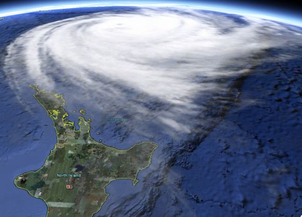
Atu dwarfing the North Island Wednesday evening – but will pass well to the east of NZ / Google Earth
Information on the system is a little more sketchy at this latitude, as it leaves the Fijian authorities and moves into MetService’s area of responsibility. However unlike Australia and Fiji, New Zealand’s government forecaster doesn’t provide tracking or specific maps and updates on tropical systems outside of their marine forecasts and normal weather charts.
WeatherWatch.co.nz instead turns to the Joint Typhoon Warning Centre in Hawaii for the latest information.
The JTWC says by 7am NZT Atu will be a category 2 cyclone with winds averaging 100km/h gusting 130km/h.
However Atu’s “tropical cyclone” status will soon no longer apply with Atu currently in the process of becoming extra-tropical – meaning he’s losing his warm core and is developing into a more “typical” low that we’d see around New Zealand fuelled by cold conditions.
However cyclone Atu still remains a serious storm that is causing rough seas around the eastern North Island. The main issue will be dangerous rips along our eastern beaches – especially dangerous with sunny, hot, calm weather at many North Island beaches over the next two days and beachgoers perhaps not realising what is happening out to sea.
People who are heading to the beach on Thursday and Friday from Northland to Bay of Plenty and from Friday to Sunday from East Cape and Gisborne to Hawkes Bay are advised to be aware of dangerous rips.
This brief video explains what rips look like and what to do if you get caught in one.

Latest map from the JTWC shows Atu losing its cyclone status at a similar latitude to Cyclone Wilma, but much further east – sparing New Zealand from destructive winds and flooding.
Comments
Latest Video

Westerlies continue, sub-tropical for some
West to north-west winds blow through the South Island and lower North Island today bring heavy West Coast rain and…
Related Articles
Westerlies continue, sub-tropical for some
West to north-west winds blow through the South Island and lower North Island today bring heavy West Coast rain and…

Westerly change this week, unsettled but large dry areas
Westerlies kick back in again this week which will bring a break to those in the east as far as…

Matariki, the long weekend + the outlook for next week
Wet weather and cloud continues along the eastern side of the country with the heaviest rain now moving into northern…


Derek on 24/02/2011 12:09am
My some people are very sad, poor Douglas cannot see what value WW gives to the general population with it’s easily understood forecasts and accompanying information. Nowhere else provides it not even the crown forecaster. We would not be aware of these major weather events if not for WW. Only find out when we get hit.
So cheer up my fellow and enjoy what the site has to offer.
PETER on 23/02/2011 10:54pm
If cyclones have names, why don’t earthquakes ??
Celtickiwi on 24/02/2011 1:34am
Good point Peter!
Lyn on 23/02/2011 7:57pm
Thanks so much for your work. Living on Kawau Island where we don’t have roads from one place to another and we either walk or take a boat to move around, I find that your information is the most accurate in terms of forecasting and watching.
With regard to your comment “New Zealand’s government forecaster doesn’t provide tracking or specific maps and updates on tropical systems outside of their marine forecasts and normal weather charts” my questions are why not and how do we get them to do so? Or do you think it is okay to just pick up on what other governemtns are doing?
WW Forecast Team on 23/02/2011 10:27pm
Hi Lyn,
Hi Lyn, very good question! We’d love to see the government doing this however I would imagine due to the rare nature of these events it’s probably considered very low priority.
However the good news is that WeatherWatch.co.nz and NZHerald.co.nz are working on improving mapping of future storms (from the tropics and elsewhere). It’s a work in progress so watch this space.
Philip Duncan
View more comments