Continuous thunder across parts of the North Island this morning
3/12/2018 8:01pm

> From the WeatherWatch archives
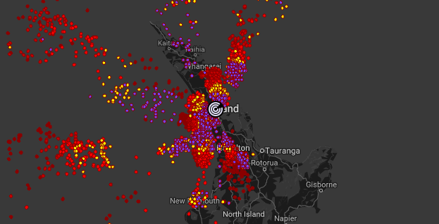
UPDATED 9:01am — A very active widespread area of thunderstorms is currently crossing the upper North Island, affecting Auckland and Waikato and soon Coromandel Peninsula, Bay of Plenty, Manawatu and Kapiti.
Some storms have generated continuous rolling thunder – especially in parts of Auckland’s.
The front is connected to a change in wind directions, from northerly to westerly and is the precursor to a cold change coming in to the South Island tonight and tomorrow.
WeatherWatch.co.nz says there have been hundreds of lightning flashes in the past hour and people should remain indoors if thunderstorms are nearby. Heavy downpours may also cause pockets of flooding. Thunderstorms are the most dangerous form of weather.
The next surge (as of 9am) was approaching Kapiti and Manawatu while the original storms in the north are tracking eastwards towards Bay of Plenty and East Cape later.
View New Zealand’s only Live and Free Lightning Tracker here (or in our Free App). www.weatherwatch.co.nz/lightning
– WeatherWatch.co.nz
Latest Video

ClimateWatch: JULY outlook & what El Niño means for NZ
El Niño is officially here and still getting stronger in the months ahead, but it’s harder to notice its effects…
Related Articles
ClimateWatch: JULY outlook & what El Niño means for NZ
El Niño is officially here and still getting stronger in the months ahead, but it’s harder to notice its effects…

Low pressure heading to NZ this weekend & into next week
Many regions have settled weather at the moment with frosts as far north as Auckland this morning, but still some…

Colder nights/mornings, polar change coming Sun/Mon
The nights and mornings ahead will be colder in a number of regions – but an even colder change is…

