Cold snap about to pounce: Rain, squalls, snow, wind, big waves and colder air (+7 Maps)
29/07/2019 8:09pm

> From the WeatherWatch archives
A nationwide cold southerly is about to pounce and will bring a week long change in our weather pattern with colder days, stronger winds and lower daytime temperatures.
While this new change will drop daytime highs it will also help lift overnight lows for some regions with windier, cloudier weather replacing the calm, clear, skies we had a week ago. In other words, frosts aren’t so likely.
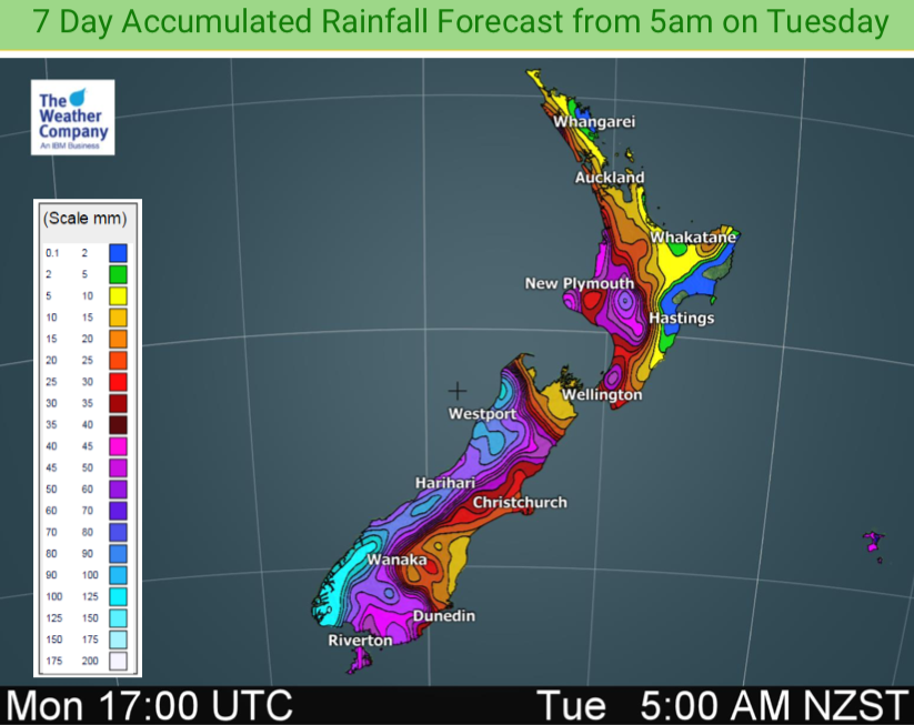
The main front is arriving today in the South Island and will take the next 24 to 36 hours to work its way northwards and by Thursday the whole country will be under the southerly – although the coldest of the air will be then already sliding away to the east of New Zealand.
It doesn’t end there either.
Over Friday and Saturday another two more cold fronts approach and dredge up a very windy westerly across New Zealand for the weekend and into the start of next week. It means temperatures will lift up for a time as the fronts moves in, then drop a little as the fronts pass over.
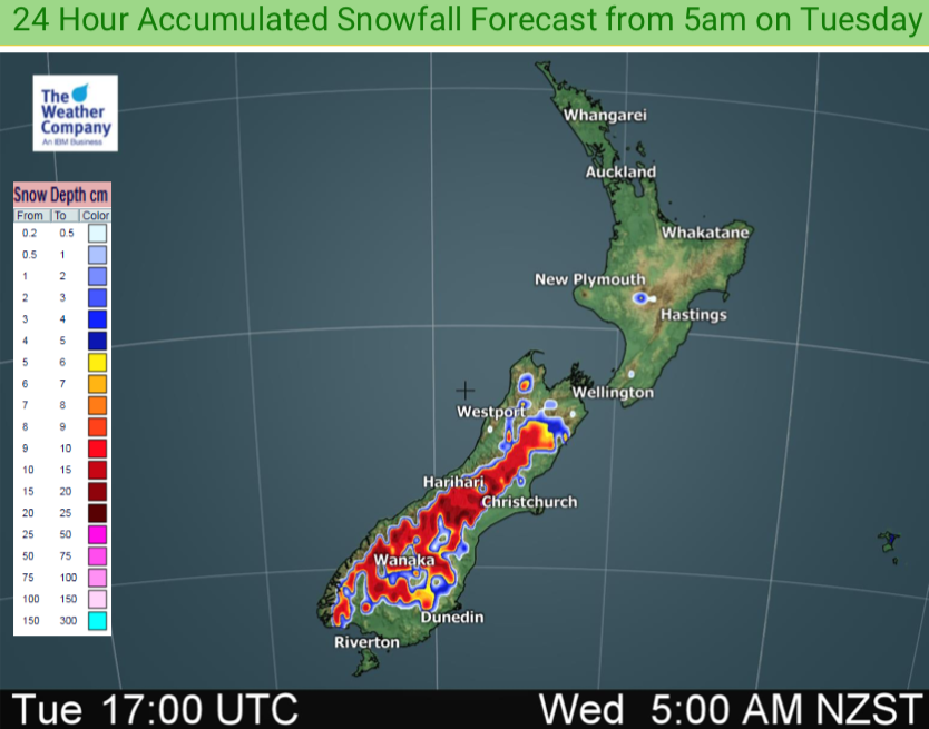
As for severe weather, we have heavy rain on the West Coast, heavy snow in the Southern Alps and down to 300m with snow flurries going lower than that in some places (but unlikely to settle). Marine conditions are dangerous, especially along the western coastline this week with big waves and gales developing. Gale force winds will also affect land in some places over the next week, mostly in the usual exposd areas for W to SW winds.
9AM TODAY (TUESDAY)
9AM WEDNESDAY:
9AM THURSDAY:


– WeatherWatch.co.nz
Latest Video

Frosts, late week rain & another cold weekend coming
High pressure will cross NZ over the next few days meaning more cold nights/mornings with frosts, but a nor’wester will…
Related Articles
Frosts, late week rain & another cold weekend coming
High pressure will cross NZ over the next few days meaning more cold nights/mornings with frosts, but a nor’wester will…

NZ: Cold & windy, then calm & frosty
Downpours, some squally with the chance of thunderstorms and even small tornadoes are possible for parts of NZ over Friday…

WeatherWatch App launches real-time local lightning tracker
A bolt out of the blue! WeatherWatch has launched a live, real-time lightning tracker, enabling Kiwis to gain access to data provided by the…

