Christmas Day crystal ball – It’s looking colder for some (+2 Maps)
17/12/2019 9:19pm

> From the WeatherWatch archives
Updated Wednesday AM — The latest for Christmas Day shows some parts of NZ will likely be colder than normal with showers still possible but high pressure also growing.
Christmas Day appears to be a colder one along the eastern side of New Zealand where showers still look likely to form.
RAIN / SHOWERS:
No real rain is forecast for Christmas Day over NZ. At this stage it looks more like showers will form here and there, especially in two areas: 1) Along the eastern side of NZ. 2) Potential isolated afternoon downpours through some inland parts of the North Island.
Two of the higher risk areas for showers appear to be Canterbury and Wairarapa at this stage, caught up in the cooler East to South East wind flow.
TEMPERATURES:
Christmas Day may feel more like a Northern Hemisphere winter this year with daytime highs in some places possible as low as 12 degrees. The following places are currently forecast to have highs between 12 and 15 degrees on Christmas Day (please note this may change but here’s the latest thinking).
- Dunedin
- Invercargill
- Oamaru
- Ashburton
- Timaru
- Christchurch
In the North Island other places look to be cooler than normal, at this stage eastern areas look to have highs in the mid to late teens, in places like:
- Wellington
- Masterton
- Napier
- Gisborne
Slight changes in windflows may alter the above – but the closer we get to December 25th the more likely the data will start to lock in.
Below shows the current modelling which is continuing to build a picture of high pressure growing to our west and low pressure to our east encouraging a few showers. Daytime heating, especially inland, may trigger some bigger but isolated showers through central and western parts of the North Island – we’re just covering possibilities based on the data at this early stage. We should be able to confirm more details later this week and into the weekend.
Warmest areas look to be in the very north of NZ and areas leaning west.
WHAT THE MODELS ARE SAYING FOR 12 NOON DECEMBER 25
ECMWF (Too far out to show rain data yet, so just air pressure lines)
GFS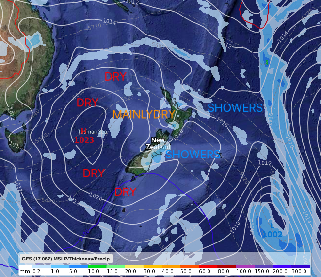
– WeatherWatch.co.nz
Latest Video

Cold weekend, frosts return with high pressure, then a low late next week
The subantarctic airflow spreads over NZ today/tonight and into Saturday, dropping temperatures nationwide. Snow flurries are possible today to lower…
Related Articles
Cold weekend, frosts return with high pressure, then a low late next week
The subantarctic airflow spreads over NZ today/tonight and into Saturday, dropping temperatures nationwide. Snow flurries are possible today to lower…

Wintry burst of weather: Snow, squally showers then sunshine & frosts
A polar change (another one!) arrives on Friday for the South Island and goes nationwide on Saturday, leaving NZ under…

Antarctic southerly for parts of NZ Fri & Sat
For the first time this year a southerly from off Antarctica is heading towards the South Island, followed by more…

