
> From the WeatherWatch archives
WeatherWatch.co.nz believes that Bune is no longer a tropical cyclone based on latest predictions by the Joint Typhoon Warning Centre and latest satellite imagery.
 Throughout Tuesday Bune has lost its eye with the bulk of the rain and cloud pushing to the southern half of the depression.
Image — Low moving towards East Cape overnight / MetService
However the storm is still packing a punch with the equivalent of strong category 1 winds – averaging 85km/h this evening and gusting well over 120km/h out at sea.
The low air pressure and strong winds are continuing to create dangerous rips and surf along the east coast of the North Island with the worst yet to come.
WeatherWatch.co.nz advises beach goers to avoid the sea for the next 48 hours as the peak of the strong rips and large waves move through.
Both WeatherWatch.co.nz and the crown forecaster agree that severe weather is unlikely over land but WeatherWatch.co.nz says that big seas could drive in waves large enough to cause serious beach erosion – and that may affect some coastal properties between East Cape and Hawkes Bay in the coming 48 hours.
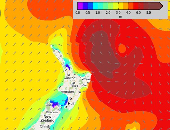
Dangerous rips and surf spread in t east coast beaches of the North Island on Wednesday / Weathermap.co.nz
Latest Video

Cold weekend, frosts return with high pressure, then a low late next week
The subantarctic airflow spreads over NZ today/tonight and into Saturday, dropping temperatures nationwide. Snow flurries are possible today to lower…
Related Articles
Cold weekend, frosts return with high pressure, then a low late next week
The subantarctic airflow spreads over NZ today/tonight and into Saturday, dropping temperatures nationwide. Snow flurries are possible today to lower…

Wintry burst of weather: Snow, squally showers then sunshine & frosts
A polar change (another one!) arrives on Friday for the South Island and goes nationwide on Saturday, leaving NZ under…

Antarctic southerly for parts of NZ Fri & Sat
For the first time this year a southerly from off Antarctica is heading towards the South Island, followed by more…

