Big Easter Weekend Storm looking likely for NZ (+5 Maps)
2/04/2020 11:00pm

> From the WeatherWatch archives
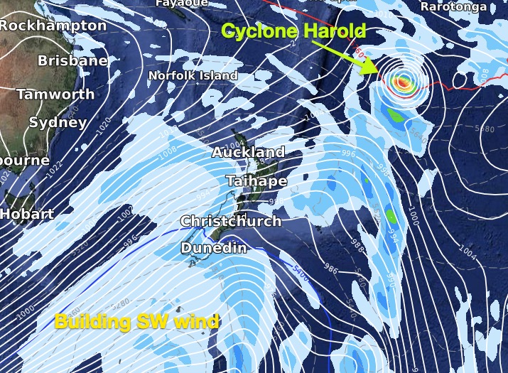
One week from now New Zealand may be facing a significant Autumn storm bringing wintry and severe weather, says WeatherWatch.co.nz.
Computer modelling continues to paint an enormous area of low pressure that will even dwarf the size of Australia as it churns directly south of New Zealand over Easter Weekend. Likely over the entire long weekend.
For farmers, growers and those in essential services we wanted to give you the early heads up that Good Friday to Easter Monday may see winter weather conditions in parts of the South Island and squally showers with severe gales extending into the North Island. It’s too early to lock in specifics as computer models may change in the days ahead in some ways which impact regions here but wintry weather looks most likely in the South Island (Southland, Otago, Westland), windiest weather is nationwide and most showers will be in the south and west of both islands. Heaviest rain looks to be on the West Coast, especially the southern half of the Coast.
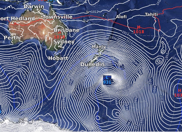
According to ECMWF air pressure near south eastern NZ may drop into the 960s hP, and latest IBM data – which you can view for free in “Detailed Data” at www.RuralWeather.co.nz – tracks barometric pressure hourly, they currently forecast Dunedin to get to 977hPa on Saturday.
NOON GOOD FRIDAY:
6PM SATURDAY:

SUNDAY 6PM:
SUNDAY 6PM – BIG PICTURE:
DUNEDIN AIR PRESSURE FOR SATURDAY:

- WeatherWatch.co.nz
Comments
Before you add a new comment, take note this story was published on 2 Apr 2020.
Latest Video

NZ VIDEO: More lows, but a reduction in severe weather
More low pressure is coming in to New Zealand this week – but rainfall isn’t as dramatic as previous weeks,…
Related Articles
NZ VIDEO: More lows, but a reduction in severe weather
More low pressure is coming in to New Zealand this week – but rainfall isn’t as dramatic as previous weeks,…

NZ VIDEO: Westerlies, lows, showers & large dry areas
Messy westerly driven weather will affect NZ this week, bringing more wet weather to western and northern parts of the…

NZ VIDEO: Westerlies continue
Heavy rain and northerly gales are moving across NZ going into the weekend as a large low from the Tasman…


Add new comment