
> From the WeatherWatch archives
12 hours ago it dwarfed the North Island, now it’s a smudge of cloud to the east of the North Island. Ex-cyclone Atu has been downgraded and has weakened considerably today but the storm is not over yet.
It remained a powerful category 3 cyclone at the same latitude that Cyclone Wilma last month was a category 2.
However, as expected, Atu transitioned into what is called an extra-tropical cyclone. This term isn’t usually used to describe storms at our latitude but in fact that’s what they are. The term is, however, commonly used when a cyclone leaves the tropics.
An extra-tropical cyclone is a storm that is outside of the tropics and has no tropical characteristics – in other words, it is fuelled by cold conditions, unlike cyclones which are warm at the centre. These are the “everyday” storms that we get in New Zealand.
The transitions takes a huge toll on a tropical storm, they lose their eye, they lose their shape and they lose a huge amount of strength. They also often lose that perfect circular shape which we see on the weather maps.
But once they get themselves sorted into an extra-tropical cyclone they can power back up again, often spreading their severe weather conditions further afield – and less concentrated around the centre.
Atu is predicted to do this in the coming 24 to 48 hours as it quickly slides into the Southern Ocean and well away from land.
Before it leaves it will continue to produce dangerous rips and beach conditions along the east coast of the North Island from Northland to Wairarapa, with conditions easing north west of East Cape tomorrow and elsewhere by Sunday.
Atu is still packing a punch – the crown forecaster says in their Marine Warning that Atu has sustained winds of 110km/h, although their most recent update was at 7:35am, one can assume those winds are now much lower.
– WeatherWatch.co.nz
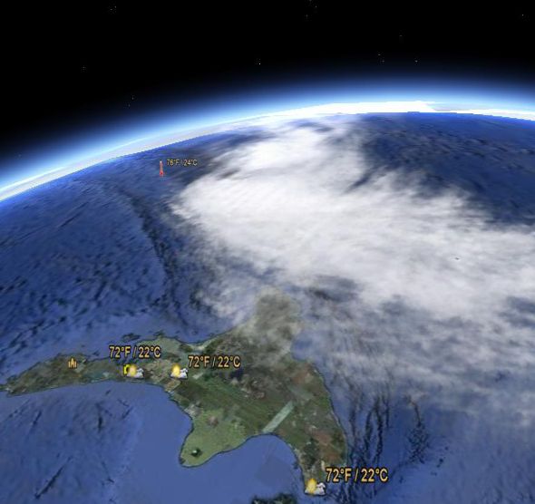
Latest view of Atu looking north east towards East Cape in the distance / Google Earth
Comments
Latest Video

Westerlies continue, sub-tropical for some
West to north-west winds blow through the South Island and lower North Island today bring heavy West Coast rain and…
Related Articles
Westerlies continue, sub-tropical for some
West to north-west winds blow through the South Island and lower North Island today bring heavy West Coast rain and…

Westerly change this week, unsettled but large dry areas
Westerlies kick back in again this week which will bring a break to those in the east as far as…

Matariki, the long weekend + the outlook for next week
Wet weather and cloud continues along the eastern side of the country with the heaviest rain now moving into northern…


stu on 24/02/2011 9:38am
HI,
So we all know that hurricanes/cyclones/typhoons whatever you call them depending on your area get their strength from warm tropical waters and when they head out of the tropics they basically die down.
My question is… I hear about the big polar storms that rip down from the arctic causing chaos on europe/north america etc. Watched a brilliant BBC doco actually about wind, cold, heat and…cant remember.. but it touched on the awesome power of arctic storms and said the highest recorded wind speeds (except tornadoes) were actually on mt washington and these were from arctic storms…(i think at least from memory, dont quote me)
Are there actually storms from the poles to match a hurricanes strength? or is just bad cause they are also dumping snow etc etc etc…
westcoast on 25/02/2011 7:18am
with those NE USA storms, you have the combination of cold air from Greenland and then the cold air from Canada, that moves down across the apalachian mountains, as a lee trough (helps rapid deepening, lows being tucked in behind a mountain range like that), and then that cold air colides with the warmer air that is fueled by the gulf stream off New York…a potent combination
i.e the lows deepen rapidly in the New foundland area
also Mt Washington is shaped in such a way to greatly accelerate the wind flow over it, and it just so happens you can drive to the top and so there is a manned station there (so that they can de ice the equipment)
Mt John Observatory in Inland Canty similarly records very high windspeed at times