Anticyclonic Gloom for western New Zealand + ANZAC dawn outlook (+4 Maps)
22/04/2018 11:03pm

> From the WeatherWatch archives
As WeatherWatch.co.nz said last week the high pushing in across New Zealand this week won’t be bringing sunny weather for everyone, especially those who live in the western side of either main island.
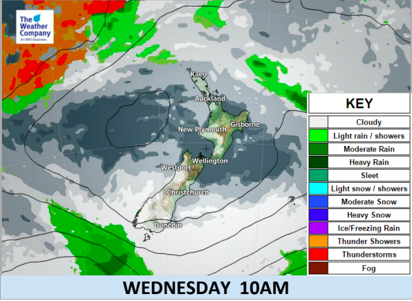
Anticyclonic gloom is simply cloud trapped underneath a big high and once we’re on the winter half of the year the nights are longer than the days and that coupled with light winds and warm seas helps create a blanket of cloud that can’t be blown away. As you can see in the info-graphics below the western side of the country is fairly cloudy.
Wednesday morning may be cold in a number of regions due to light winds following light sou’westers on Tuesday. There may be some frosts inland and towards the east which will have much clearer skies.
ANZAC DAY:
The forecast for ANZAC day could not be better, it’s one of the best forecasts we’ve had in years for New Zealand thanks to a very large high that will be parked smack bang over the top of the nation. This ensures mostly light winds and dry weather from Northland to Southland, Westland to Eastland. There is a very slight chance of some early showers in Northland which will be clearing around dawn.
Temperature-wise and dawn ceremonies will be a little cooler on Wednesday morning but not freezing for most. Frosts are possible through the South Island highlands and parts of Otago. It’ll be cold in the single digits first thing but overall Wednesday looks pleasant and mild for most regions by lunchtime.
Weather Highlights:
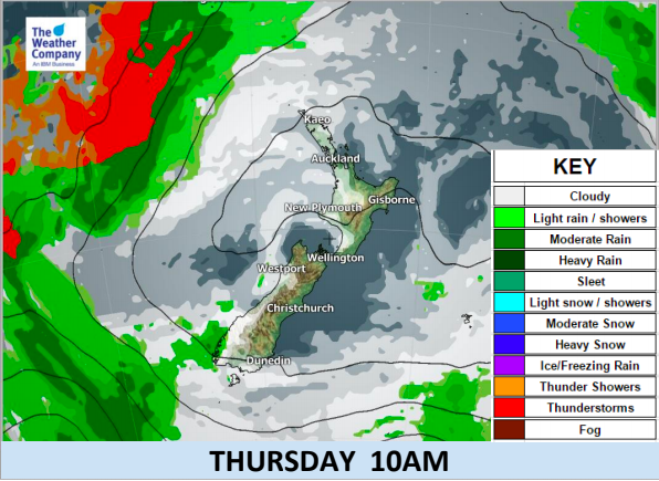
- The high will stay over the northern part of New Zealand for the rest of this week, keeping basically good weather almost countrywide for the second week of the school holidays.
- A brief break in this regime will occur in Southland and southern West Coast from this afternoon to Tuesday morning as a few showers move northwards.
- After Tuesday evening it will be clear again over most of the country but again cloudy weather may remain in the west.
- Sunny weather will prevail until Friday in the east and inland.
- Clear skies on Tuesday night will cause morning chills again on Wednesday for ANZAC dawn parades – but nothing too major.
- Frosts are possible in the highlands on Wednesday morning and perhaps even a little lower down for some South Island regions.
- Foggy spells are possible mid to late week in the North Island as the centre of the high transfers from the Tasman Sea to the Pacific Ocean (from centred to our west to being centered to our east).


– WeatherWatch.co.nz – Official New Zealand business partners of IBM and The Weather Company
Latest Video

Pockets of hit & miss heavy rain, snow moves northwards
Low pressure continues to slowly move across the upper North Island and for some that will bring the sun out,…
Related Articles
Pockets of hit & miss heavy rain, snow moves northwards
Low pressure continues to slowly move across the upper North Island and for some that will bring the sun out,…

Slow go for northern low & southern cold
For the next few days low pressure will crawl over the upper North Island, driving in rain as far south…

Slow moving low to track over northern NZ
A low pressure zone will slowly cross the North Island over the coming days, bringing hit and miss pockets of…

