
> From the WeatherWatch archives
Tuesday is set to be action packed, with a northwesterly airflow over New Zealand and then a low barrelling towards the South Island out of the Tasman Sea.
This low pressure system crosses over the South Island from west to east during the day – it’s moving fairly quickly – and as it passes out to the east, we see a cold southerly airflow come in behind it.
As well as this, a front associated with the low pushes over the lower South Island in the morning, over the upper South Island in the afternoon, and then onto the North Island in the evening – coming in from the west.
The South Island has rain in the west, with heavy falls and possible thunderstorms, while high cloud thickens in the east with spots of rain for a time.
Southerlies in the evening and overnight then bring rain to the east coast.
Rain moves into Southland & Otago in the morning again, with southerly winds, and even some snow lowering to about 300m by evening.
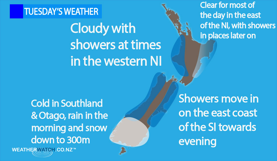
It’s looking like a cloudy day for the North Island out west, with the odd patchy shower possible, then during the evening some rain moves in from the west.
In the east, it’s shaping up to be mainly sunny – with high cloud from afternoon, along with spots of rain possible about the Wairarapa, and then Hawkes Bay & Gisborne later in the day, spreading from the west.
– Aaron Wilkinson & Drew Chappell, WeatherWatch.co.nz
Comments
Before you add a new comment, take note this story was published on 2 Nov 2015.
Latest Video

VIDEO: Another big low late week brings severe weather risks to NZ
Severe weather is back in the forecast later this week after we kick off July with high pressure at the…
Related Articles
VIDEO: Another big low late week brings severe weather risks to NZ
Severe weather is back in the forecast later this week after we kick off July with high pressure at the…

VIDEO: NZ 7 Day: One big low, a high, then another big low
Severe weather risks continue around NZ’s two main islands for the rest of Friday and going into Saturday, before conditions…

VIDEO: Severe weather for parts of NZ, ahead of more high pressure
A large low in the Tasman Sea will bring further heavy rain and strong winds to western and southern parts…


Add new comment