A couple of colder nights on the way before warmer nor’westers (+5 Maps)
21/06/2021 9:04pm

> From the WeatherWatch archives
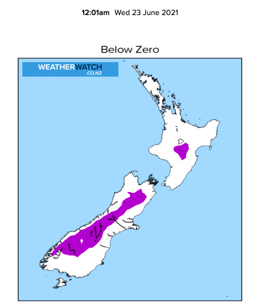
Frosts are in the forecast for both islands over the next couple of nights and temperatures drop further north following a southerly flow today.
The colder air will linger until Thursday morning bringing colder than average weather, especially for the North Island.
WeatherWatch.co.nz says frosts will make it as far north as Waikato and even sheltered parts of Auckland over the next couple of nights.
But it’s short lived.
By Thursday night milder air moves in with overnight lows in Southland over 4 degrees above normal by Friday morning. That milder air then moves northwards covering all of NZ this weekend. It won’t last too long though. By Monday next week a wintry southerly returns to the country.


Latest Video

More eastern rain, but a drier long weekend coming
Rain continues today along the eastern South Island and lower North Island, coming in from the east with heavy falls….
Related Articles
More eastern rain, but a drier long weekend coming
Rain continues today along the eastern South Island and lower North Island, coming in from the east with heavy falls….

More heavy rain, snow – but large dry areas, especially as we go into the long weekend
Heavy rain will continue for parts of Canterbury and Marlborough over the next day or two and it will gradually…

Large low brings rain, downpours & some snow – gets colder as the week progresses
Low pressure will cross the upper North Island in the days ahead and that set-up actually pushes more heavy rain…

