
> From the WeatherWatch archives
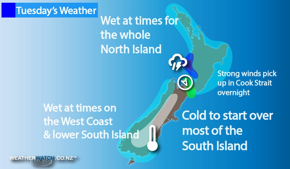
It’s a wet start for most as a low pressure system moves over the North Island, moving from west to east during the morning and afternoon.
Most regions naturally should see some morning rain then clear away during the afternoon, while the East Coast of the North Island sees rain develop a little later in the morning then clear a little later in the afternoon compared to elsewhere.
For Taranaki there may be a heavy fall and thunderstorm in the morning.
Winds blow mainly from the north, then tend west to southwest in the afternoon.
For the South Island, the day starts off a little cold with frosty conditions – nothing earth shattering, but cold nonetheless, and then it’s a mainly sunny day for most.
A few morning showers are possible for Nelson & Marlborough then clearing away.
Some high cloud develops about Southland & Otago in the evening.
A few showers about Fiordland during the day turn to rain in the evening, becoming heavy then spreading northwards along the West Coast overnight – along with possible thunderstorms.
A few spots of rain are possible overnight for Southland & Otago also, and perhaps Canterbury by dawn on Wednesday.
Northwesterly winds pick up overnight about Cook Strait too.
– Aaron Wilkinson & Drew Chappell, WeatherWatch.co.nz
Latest Video

Cold weekend, frosts return with high pressure, then a low late next week
The subantarctic airflow spreads over NZ today/tonight and into Saturday, dropping temperatures nationwide. Snow flurries are possible today to lower…
Related Articles
Cold weekend, frosts return with high pressure, then a low late next week
The subantarctic airflow spreads over NZ today/tonight and into Saturday, dropping temperatures nationwide. Snow flurries are possible today to lower…

Wintry burst of weather: Snow, squally showers then sunshine & frosts
A polar change (another one!) arrives on Friday for the South Island and goes nationwide on Saturday, leaving NZ under…

Antarctic southerly for parts of NZ Fri & Sat
For the first time this year a southerly from off Antarctica is heading towards the South Island, followed by more…

