
> From the WeatherWatch archives
It’s been a windy, restless, night for a lot of New Zealanders thanks to the gusty colder change moving up the nation – and winds may increase before easing today for some, mainly in the east.
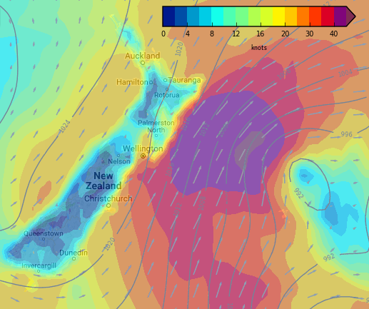
Low pressure east of Otago and Canterbury will track northwards today and between this lower air pressure and the huge high over eastern Australia the pressure gradient is very steep around the eastern coastline of New Zealand – this is then creating hurricane force winds out at sea (120km/h) and gales brushing land (over 61km/h).
This places coastal areas in the path of gales today (again the worst is out to sea but as these strong winds move up the coastline they will brush some eastern communities – places like Banks Peninsula are especially exposed).
The gusty winds move up the east coast – while at the same time winds on the western coastline should ease across today.
By tonight the blustery change will be hugging the east coast of the North Island while easing in the South Island. It will ease overnight in the east of the North Island.
Thursday looks much calmer nationwide, with westerlies developing over the day in many areas.
 9am Wind Map – Wednesday (blue = light wind, purple = strongest winds)
– Wednesday (blue = light wind, purple = strongest winds)
– WeatherWatch.co.nz
Latest Video

Cold weekend, frosts return with high pressure, then a low late next week
The subantarctic airflow spreads over NZ today/tonight and into Saturday, dropping temperatures nationwide. Snow flurries are possible today to lower…
Related Articles
Cold weekend, frosts return with high pressure, then a low late next week
The subantarctic airflow spreads over NZ today/tonight and into Saturday, dropping temperatures nationwide. Snow flurries are possible today to lower…

Wintry burst of weather: Snow, squally showers then sunshine & frosts
A polar change (another one!) arrives on Friday for the South Island and goes nationwide on Saturday, leaving NZ under…

Antarctic southerly for parts of NZ Fri & Sat
For the first time this year a southerly from off Antarctica is heading towards the South Island, followed by more…

