White Island: Update on eruption (+2 Animated Satellite Maps of ash cloud)
13/09/2016 4:26am

> From the WeatherWatch archives
GeoNet has updated New Zealanders on the conditions at White Island. We also have two satellite animations showing the eruption today.
Here is the full statement from GeoNet:
VOLCANIC ALERT BULLETIN: issued 15:15 Tuesday 13 September 2016
Volcanic Alert Level 3 (no change)
Aviation Colour Code: Orange (no change)
As far we can tell from our monitoring data there has been no escalation in the level of activity at White Island since late morning. Seismic activity remains low on the island. Some of our cameras are now been affected by ash and steam, so we may not see much from them in the short term.
The level of volcanic activity seen earlier today was very minor, with volcanic ash been passively emitted from a vent on the 2012 lava dome.
The ash is visible on a NZ Metservice visible satellite image [not provided] which shows a plume extending offshore of East Cape. Any ash fall will follow wind direction and is likely to be blown offshore over the next day.
The current activity is minor. We will review the situation in the morning unless changes occur overnight. Implications for visitor safety remain unclear.
– By Steve Sherburn, Duty Volcanologist – GeoNet
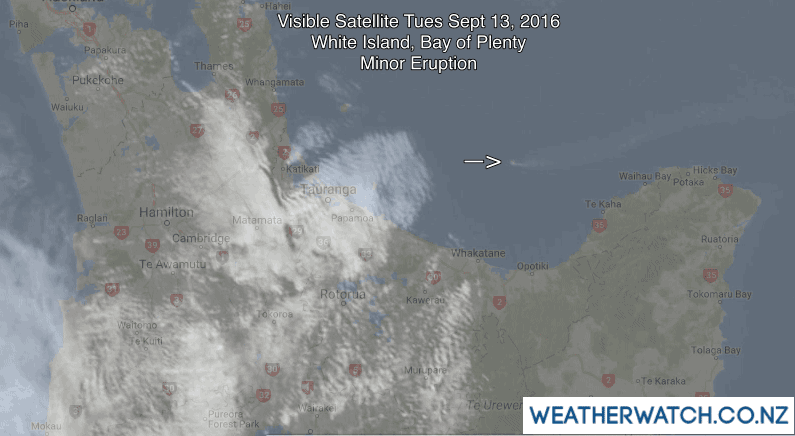
As you can see in the GIFs both above and below (from the past few hours) the ash cloud can clearly be seen coming out of White Island in the Bay of Plenty, then out towards northern East Cape and over the Pacific Ocean.

– GIFs / WeatherWatch.co.nz with international data.
– WeatherWatch.co.nz
Latest Video

Wintry weather coming: Snow, rain, wind & sunshine
A cold front is moving into NZ from Friday to Sunday with low pressure developing west of NZ and then…
Related Articles

Polar airflow + northern low = pockets of heavy rain & snow
A colder change is coming – and so too is a large low which will develop and grow over northern…
Wintry weather coming: Snow, rain, wind & sunshine
A cold front is moving into NZ from Friday to Sunday with low pressure developing west of NZ and then…

ClimateWatch: JULY outlook & what El Niño means for NZ
El Niño is officially here and still getting stronger in the months ahead, but it’s harder to notice its effects…

