Wet western weather on the way (+4 maps)
10/08/2021 7:58pm

> From the WeatherWatch archives
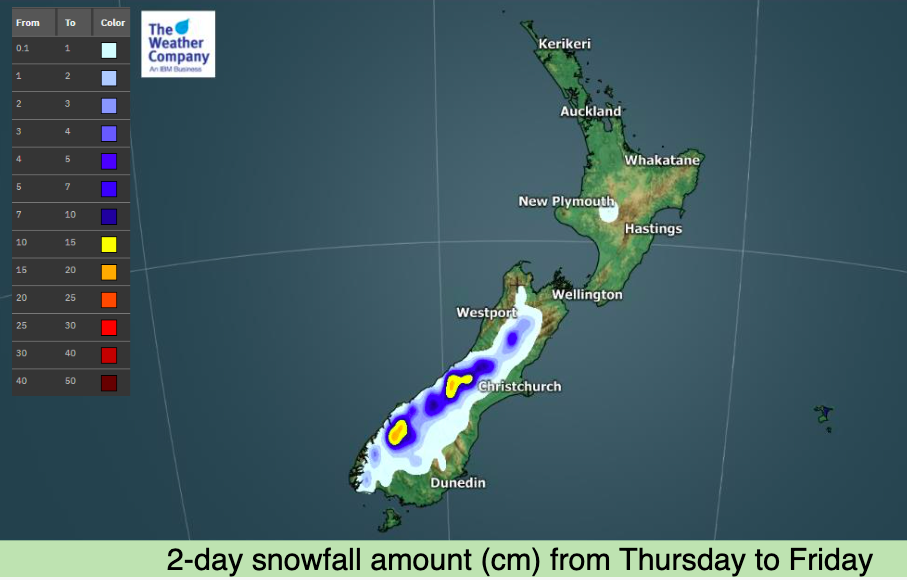
More heavy rain and snow are on the way for parts of New Zealand, especially the western half of the South Island.
The eastern and northern sides of NZ look fairly dry with only a few showers and low accumulation overall.
The West Coast has two bursts of rain this week and again at the weekend. The combined accumulation looks to be over 200mm in some areas, but in the places we most expect it – ie, Fiordland and the southern half of Westland.
The Nelson Ranges and Westport area do get clipped by some of this rain, but it’s basically within the margins of ‘normal’ weather. However those impacted by slips and floods recently should monitor local rainfall totals via RuralWeather.co.nz and WeatherWatch.co.nz (our rainfall totals are hyper-local to your area and are generated by IBM Watson, the most accurate rain forecaster in NZ).
Colder air will also see rain turn to snow in the mountains with heavy falls and up to one metre of snow possible between now and midnight Sunday.


Comments
Before you add a new comment, take note this story was published on 10 Aug 2021.
Latest Video

NZ VIDEO: More lows, but a reduction in severe weather
More low pressure is coming in to New Zealand this week – but rainfall isn’t as dramatic as previous weeks,…
Related Articles
NZ VIDEO: More lows, but a reduction in severe weather
More low pressure is coming in to New Zealand this week – but rainfall isn’t as dramatic as previous weeks,…

NZ VIDEO: Westerlies, lows, showers & large dry areas
Messy westerly driven weather will affect NZ this week, bringing more wet weather to western and northern parts of the…

NZ VIDEO: Westerlies continue
Heavy rain and northerly gales are moving across NZ going into the weekend as a large low from the Tasman…


Add new comment