Weekend Weather: Heavy rain in the west, windy in the east/central NZ (+7 Maps)
5/07/2018 11:43pm

> From the WeatherWatch archives
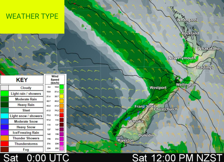
A sharp cold front extending from a polar low pressure area hits southern coastal areas today bringing heavy rain to the south western corner of the South Island then over the next few days up the entire western coastline of New Zealand.
In fact continuous rain, including ice at times, is expected around Fiordland over the next few days. Over 200mm of precipitation is forecast for the next 24 hours.
Once again this system brings strong northerlies to the South Island which will tilt NW and lead to warmer than normal temperatures this weekend. Some places may be up to 8 degrees warmer than average on Saturday or Sunday, mainly in the east of New Zealand where daytime highs may even break the 20 degrees mark.
After the rain, strong south to south west winds are expected to come on Monday, which will bring high waves and colder than usual temperatures in both islands. Waves around western Auckland may be several metres high as a result of the windy SW change arriving later on Monday.


– WeatherWatch.co.nz
Comments
Before you add a new comment, take note this story was published on 5 Jul 2018.
Latest Video

VIDEO: Severe weather risks for NZ as low moves in
A storm in the Tasman Sea peaks today in power, then drifts towards New Zealand over Thursday to Saturday as…
Related Articles
VIDEO: Severe weather risks for NZ as low moves in
A storm in the Tasman Sea peaks today in power, then drifts towards New Zealand over Thursday to Saturday as…

VIDEO: ClimateWatch: July is the month of BIG lows, BIG highs
This month around New Zealand, Australia and the region we see big highs and big lows – bringing decent stretches…

VIDEO (NZ): Large low looms – who gets rain/wind & who does not
Another large low will bring severe weather to parts of both main islands of NZ this week, followed by a…


Add new comment