Waitangi Day – Colder than normal for many after warmer than usual start to week (+4 Maps)
4/02/2019 11:21pm

> From the WeatherWatch archives
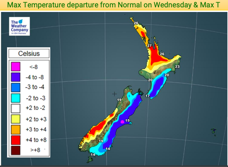
For many New Zealanders in the east this Waitangi Day will be colder than normal with temperatures down several degrees in some places thanks to a southerly change on the way – except for Waitangi itself which will be warmer than usual.
Yesterday and Tuesday are both hotter than average in a large portion of the country as high pressure drifts east of NZ allowing warmer winds. By late Tuesday and across Wednesday a colder airflow from the Southern Ocean will sweep up the eastern side dropping temperatures.
At the end of Tuesday temperatures will be lowering back to normal in Southland and parts of Otago then go below normal for Waitangi Wednesday.
In fact on Waitangi Day itself parts of Southland, Otago, Canterbury, Marlborough, Nelson, Wellington, Wairarapa, Manawatu, Horowhenua and Hawke’s Bay will be a few to several degrees below normal for February 6th.
But not all will be cooler. Waitangi itself, along with all of Northland, will be warmer than average as will Auckland, Coromandel Peninsula, Waikato, Bay of Plenty, King Country and parts of the West Coast.
In the maps below, the areas with colouring/shading have normal temperatures for this time of the year.
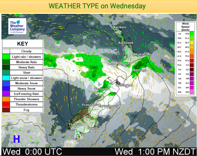
Despite the cool many places will be dry or fairly dry but cloud cover may be heavier for some in the east. Showers are most likely in the upper South Island and eastern North Island around Hawke’s Bay.


– WeatherWatch.co.nz
Comments
Latest Video

Cold weekend, frosts return with high pressure, then a low late next week
The subantarctic airflow spreads over NZ today/tonight and into Saturday, dropping temperatures nationwide. Snow flurries are possible today to lower…
Related Articles
Cold weekend, frosts return with high pressure, then a low late next week
The subantarctic airflow spreads over NZ today/tonight and into Saturday, dropping temperatures nationwide. Snow flurries are possible today to lower…

Wintry burst of weather: Snow, squally showers then sunshine & frosts
A polar change (another one!) arrives on Friday for the South Island and goes nationwide on Saturday, leaving NZ under…

Antarctic southerly for parts of NZ Fri & Sat
For the first time this year a southerly from off Antarctica is heading towards the South Island, followed by more…


Guest on 5/02/2019 1:36pm
is nuts august isn’t colder than july so why should feb be hotter than jan its all a lie as its starting to get darker in the mornings now summers is on the way out even thoe its playing these heat wave tricks