
> From the WeatherWatch archives
See the live and free Lightning Tracker.
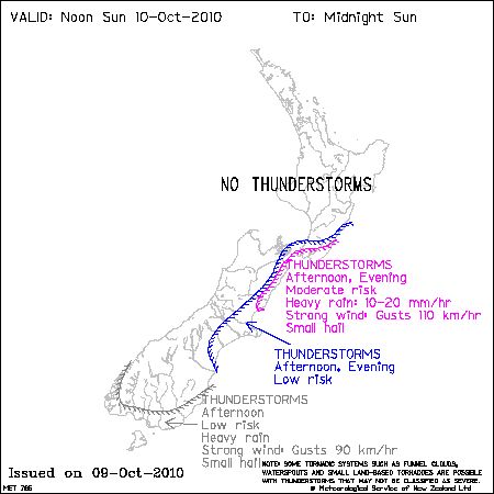
A fresh cold outbreak is expected to move onto the South Island this morning.
MetService says the airmass behind the cold front is expected to become more unstable through the period with heavy, squally showers expected in a southwesterly flow.
“There is a moderate risk that a few of these may well be thundery from about day break. Wind gusts to 90km/hr can be expected with many of the larger cells and snow is expected to low levels” says the crown forecaster.

The crown forecaster says the deep instability over the south of the South Island is expected to ease during this afternoon, but there is a lowering risk of the odd thunderstorm moving onto Southland and eastern Otago in early afternoon.
“Further north, the front mentioned earlier, will move up the Kaikoura Coast in the afternoon to reach the Cook Strait late afternoon/early evening, supporting a vigorous southerly change. There is a least a moderate risk of thunderstorms developing on this change as it moves up the Kaikoura Coast and through the Wellington area towards evening. This feature is expected to become very well organised and will support a brief period of heavy rain and very strong wind gusts. At this time, indications are that gusts may reach 110km/hr. North of Wellington, the activity on this front is expected to decrease quite quickly” says MetService’s Thunderstorm Outlook, funded by the NZ Govt.
There is lower risk of thunderstorms in a surrounding area from east Wairarapa to northeast Marlborough and down to include much of Canterbury. The Canterbury risk is really for the first part of the afternoon.
Maps courtesy of the NZ Govt
Comments
Before you add a new comment, take note this story was published on 9 Oct 2010.
Latest Video

VIDEO: Severe weather risks for NZ as low moves in
A storm in the Tasman Sea peaks today in power, then drifts towards New Zealand over Thursday to Saturday as…
Related Articles
VIDEO: Severe weather risks for NZ as low moves in
A storm in the Tasman Sea peaks today in power, then drifts towards New Zealand over Thursday to Saturday as…

VIDEO: ClimateWatch: July is the month of BIG lows, BIG highs
This month around New Zealand, Australia and the region we see big highs and big lows – bringing decent stretches…

VIDEO (NZ): Large low looms – who gets rain/wind & who does not
Another large low will bring severe weather to parts of both main islands of NZ this week, followed by a…


Add new comment