
> From the WeatherWatch archives
Wednesday sees an end to the break in the rough weather on Tuesday – as heavy rain, strong winds and thunder all return through the midweek.
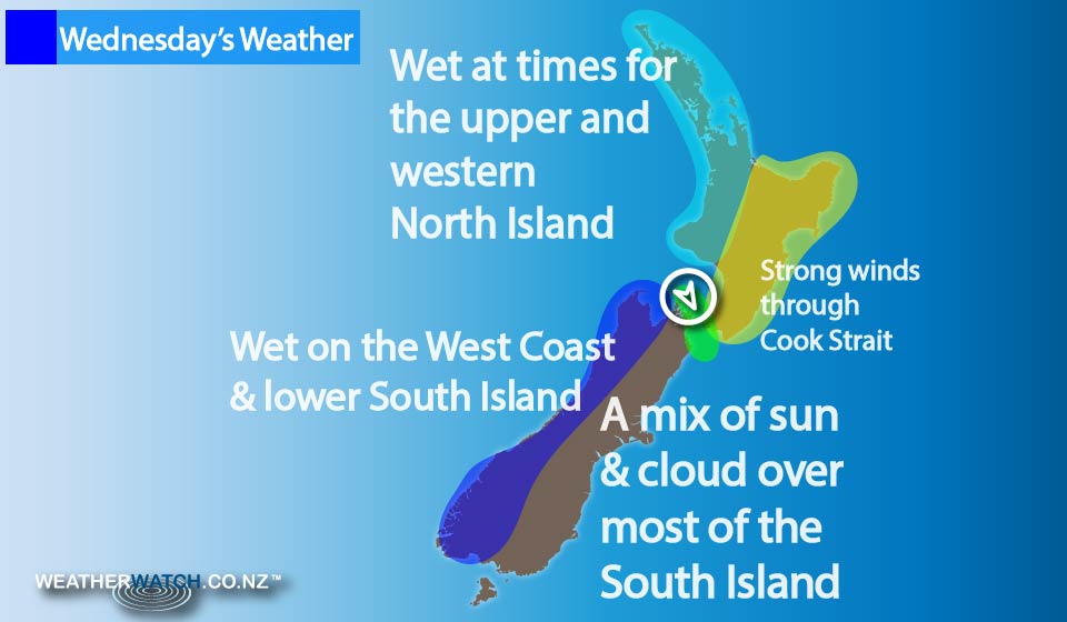
Sunny areas and increasing cloud dominate the upper North Island on Wednesday, along with the chance of a shower from midday.
There are long dry spells in the forecast also, along with winds from the northwest.
There’s the chance of a morning shower for the western North Island, from Taranaki to Kapiti, and then sunny areas develop in the afternoon, along with west to northwest winds.
Rain moves onto Taranaki at night.
On the East Coast, from Gisborne to Wairarapa a mainly sunny day is in store, along with west to northwest winds.
Heavy rain for the West Coast of the South Island clears early on, though more rain falls from afternoon about South Westland, then spreading northwards overnight with heavy falls and possible thunderstorms, too.
Any early spots of rain clear the East Coast of the South Island, then it becomes mostly sunny, along with north to northwesterly winds.
High cloud develops again about Otago & Southland from afternoon, then further north in the evening.
A few spots of rain are possible for eastern regions overnight, spreading in from the west.
– Aaron Wilkinson & Drew Chappell, WeatherWatch.co.nz
Latest Video

Matariki, the long weekend + the outlook for next week
Wet weather and cloud continues along the eastern side of the country with the heaviest rain now moving into northern…
Related Articles
Matariki, the long weekend + the outlook for next week
Wet weather and cloud continues along the eastern side of the country with the heaviest rain now moving into northern…

More eastern rain, but a drier long weekend coming
Rain continues today along the eastern South Island and lower North Island, coming in from the east with heavy falls….

More heavy rain, snow – but large dry areas, especially as we go into the long weekend
Heavy rain will continue for parts of Canterbury and Marlborough over the next day or two and it will gradually…

