
> From the WeatherWatch archives
This weekend a low is deepening well north of New Zealand, north of Vanuatu and Fiji. It will deepen over the warmest waters of the south west Pacific, then develop into a severe tropical cyclone.
It’s still early to lock in an exact path. Many computer models that New Zealanders look at online show a nasty storm moving towards northern New Zealand just after the middle of March. Other models that WeatherWatch.co.nz use, and rely on, show it may track well east of us. Either way – we’re somewhat in the middle of these potential pathes…and also at the end, as tropical cyclones don’t ‘technically’ live on south of about the Far North area.
So while the exact route isn’t yet confirmed, the likely general path will first take the deepening low on a meandering path through some of the tropical island nations directly north of us over the coming week. Like NZ, they may also miss a direct hit but with the storm likely to be far more intense over the warm tropical waters nations like Vanuatu, the Solomon Islands, New Caledonia and even Fiji, they will be on high alert soon due to the potential of a severe tropical storm.
Sea surface temperatures are a major component for fuelling tropical storms. The water in the 300km zone just north of Northland is much cooler than the waters around New Caledonia. This means the low may look intense as it rushes towards us after March 15th – but it’s highly likely the low will then quickly unravel and lose a lot of its energy as it, potentially, nears us.
There’s no point in focusing on any regional forecasts this far our – if the low slides 100kms further east we may have little to no impact weatherwise, so no point in stressing about it now until we can lock something in with some confidence (probably later next week). But even a nearby offshore ex cyclone can cause serious swells and deadly rips along our coastlines – and with so many Kiwis still hitting the beaches and coastlines (as the beach water is now at its warmest) and with so many computer models confirming an ex tropical low is likely to track our way, we wanted to give you the latest information we have, so you could better plan ahead.
The general forecast from WeatherWatch.co.nz for this month is that conditions still look drier rather than wetter, so if you have an important outdoor event after March 15th the general forecast hasn’t changed yet – we’re still forecasting a mostly dry weather pattern.
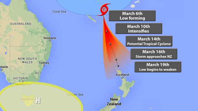
InfoGraphic: Generally speaking conditions are perfect for a storm to develop in the blue shaded area north of NZ. The red/orange shaded area is what is referred to as the “cone of uncertainty”. The black line in the middle is a rough middle ground between some of the models. However even today two new seperate sets of data suggest the low could travel another 500kms further west or east of this area. On March 19th the low may be near northern NZ – or be quickly moving away from us to the south east – so still a long way to go before we know if any serious risks for NZ – or perhaps just a weak low that might give some farmers a wet helping hand in the upper North, or even just an offshore low with some big swells for the surfers. Either way – regular updates at WeatherWatch.co.nz throughout next week. Graphic / Kimi Knight, WeatheWatch.co.nz/CountyTV.
– WeatherWatch.co.nz
Comments
Latest Video
High pressure still in charge, but a few changes in the mix
High pressure continues to control much of New Zealand’s weather although there will be some wind and temperature changes in…
Related Articles
High pressure still in charge, but a few changes in the mix
High pressure continues to control much of New Zealand’s weather although there will be some wind and temperature changes in…
Heavy West Coast rain, a few showers elsewhere
High pressure looks to remain mostly in charge of NZ’s weather until the middle of next week when a potential…
West Coast rain, a few showers elsewhere – but still high pressure holding on
Some heavy rain is coming to the West Coast and winds will change direction a few times over the week…


Guest on 8/03/2015 1:29pm
Does this storm have the potential to cause major damage and/or loss of life in New Zealand?
hitadmin on 8/03/2015 10:07pm
Hi there – no, not in New Zealand – however rips and swells will be dangerous enough to be deadly if people aren’t aware. So our main concern will be with swimmers on the east coast of the North Island from this coming Sunday through next week (especially now that the data suggests the low may not directly hit us, but be very close to our east).
– WW
cupoteacoast on 8/03/2015 8:23am
Watching WeatherWatch very closely re this menance. We get the upper winds ex Antartica via the Southern Ocean and cyclones out there tend to be very severe in Paekakariki with high windspeeds. With the Southern Ocean being hot, I suspect that cyclone will roast us, as the tropical low passing down there did in January. We’ve had humidity in the 30’s this month from that rathole, like we do in a freezing SE winter. Normally eastern cyclones pick up freezing cold air ex the South and blast us with it at high speed, oh so cold. Bola was cold and scary here. We get the same temp as Baring Head does, with the same wind speed and nil adiabatic heating either. Appreciate the early warnings Phil.
Ron on 7/03/2015 3:12am
When will it be named, and who has that job?
hitadmin on 7/03/2015 3:49am
Hi Ron,
Once the winds reach sustained gale force around the centre it will become a named storm. Who names it? – that’s where it gets a little confusing because unlike across the Americas – who all have one source out of the US, we have three govt forecasters – Fiji MetService, NZ MetService and Australia’s BOM. Aussie is west of 165E and FIJI west of that down to about New Caledonia, then it’s over to MetService – who don’t have any special cyclone products. So if it formed over the Coral Sea it would be named by Australia, but this is likely to form north east of New Caledonia so we expect the Fijians to name it. But some times a cyclone can zig zag between the 3 official forecast zones out of Aussie, Fiji and then NZ and it can be a bit messy/confusing as one stops coverage and you wait several hours for the others to start up again. Aussies do a great job at covering it – as good as the Americans in our view. We’re working on making one place to get all this info here at WW (so you don’t have to search through a number of sources – it’s in the pipeline for our next cyclone season).
Cheers
Phil D
Dave on 6/03/2015 10:59pm
Great coverage Phil & team. It looks a very large system so the tenticles will reach a long way. I will be very interested to see what does but what I do notice is there could be a perfect doorway for it to enter between highs. I hope for the rural folk it brings rain but we can do without the severe wind. Keep up the great work. Dave
Ben on 7/03/2015 8:58am
Looks like we nay get some epic surf from this one! Any forecasts on swell height?
WW Forecast Team on 7/03/2015 8:01pm
The swell maps in the “maps” tab at the top of this page are your friend 🙂
WW