The cold outbreak begins in the south – Your Weather Highlights for the next 3 days
2/08/2016 7:00pm

> From the WeatherWatch archives
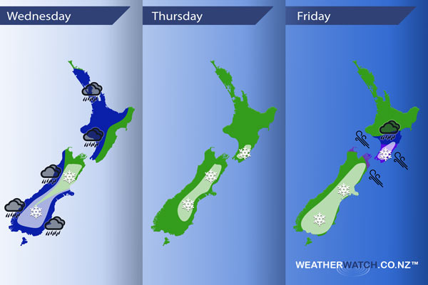
Today marks the start of a cold outbreak over the South Island which may bring heavy snow to the Canterbury and Otago high country. Tomorrow continues the cold trend over the South Island with heavy snow possible about the eastern high country, gradually easing though. Then on Friday the day starts off fairly calm but from afternoon conditions deteriorate as a southeasterly airflow strengthens.
Wednesday
Blue – Rain for the West Coast of the South Island may be heavy in the morning then easing afternoon. From afternoon rain becomes fairly persistent about Southland, Otago and perhaps parts of South Canterbury through to Banks Peninsula. For the North Island, we see heavy rain move onto the southwestern corner of the Island in the afternoon then push north in the evening.
White – While a large area of the inner South Island is covered with a snow highlight area. Snow will hit different parts of the South Island at different times due to the complex nature of a pair of low pressure systems moving over the South Island during today. At this stage snow is looking to fall to around 600m about Southland, Otago and parts of South Canterbury then push northwards overnight. Snow lowers overnight to 400 or perhaps even 300m Mid Canterbury southwards. Snow is looking to be heavy in the high country for most, although not becoming heavy for North Canterbury till overnight.
Thursday
White – Snow for much of the east of the South Island above the levels mentioned below, easing in the evening and perhaps clearing for many. The heaviest falls are mainly about inland Canterbury / Marlborough. Otago and Southland will see any early snow flurries to low levels clear, then mainly dry with cloudy periods and perhaps even some sun. Snow to 300m about Mid and South Canterbury. Snow flurries about North Canterbuy start out around 500m then lower to 300m by evening. Snow about Marlborough to 500m lowers to 400m by evening.
The lower North Island also sees some snow down to 600m from afternoon.
Friday
White – Not much activity in the morning for the east of the South Island, however from midday showers move in with snow flurries to low levels (200 to 100m), perhaps even near sea level. The snow level for Marlborough sits around 300m and the lower North Island around 400m.
Blue – From afternoon, as a southeasterly airflow strengthens, there may be some heavy rain about the lower North Island, continuing overnight.
Purple – Southeasterlies ramp up about central New Zealand from afternoon, with winds gusting to gale about coastal areas from evening.
– Please note, the idea behind this update is to focus on the main weather highlights, which is why not all regions are mentioned.
For specific 10 day information for your city, town, rural community or island please see the 1000 forecasts on our homepage!
– Aaron Wilkinson, WeatherWatch.co.nz
Comments
Before you add a new comment, take note this story was published on 2 Aug 2016.


Add new comment