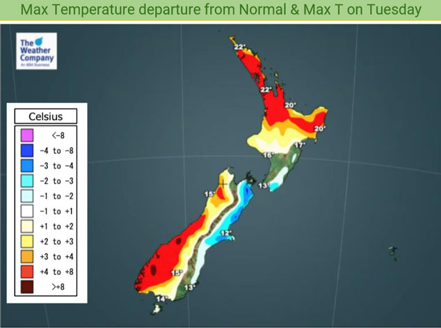
Temperature trends – Warm in the west and north on Tuesday
26/10/2020 3:00am

> From the WeatherWatch archives
A front lies over central New Zealand on Tuesday, trailing this front is an easing southerly quarter airflow and this shows with cool temperatures tomorrow for eastern parts of the South Island. North of about Hawkes Bay temperatures warm up in the east. The upper North Island has a generally settled day but expect a few areas of cloud, warm afternoon temperatures getting into the low twenties for most. The West Coast of the South Island, especially about South Westland has warm weather due to a southeasterly airflow.
Tomorrow’s coolest highs will likely be about Dunedin through to Wellington around 13 degrees.

A ridge of high pressure broadens out over the South Island overnight Tuesday / early Wednesday morning. This leads to cold temperatures by dawn on Wednesday morning, frosts may not occur but it will get close with lows down to around 1 or 2 degrees south of around South Canterbury about inland areas away from the coast although as in the map below even Invercargill may get down to 1 or 2 degrees by dawn on Wednesday morning.
The warmest overnight lows will be about Bay Of Plenty through to Northland getting down to between 14 to 15 degrees.

For Max & Min NZ Temperature maps for the next few days and nights ahead, please visit our new maps page: https://www.weatherwatch.co.nz/maps-radars/temperature/temperature
By Weather Analyst Aaron Wilkinson – WeatherWatch.co.nz
Comments
Before you add a new comment, take note this story was published on 26 Oct 2020.


Add new comment