Snow falls in Hokitika, also near Greymouth, Invercargill (+Photos & Video)
4/08/2019 1:10am

> From the WeatherWatch archives
UPDATED 1:30pm — WeatherWatch.co.nz said sea level snow was likely in Fiordland and South Westland today, but right now parts of Hokitika and Greymouth have isolated snow flurries too.
The polar blast is moving up the South Island and will track over the North Island later today, dropping temperatures nationwide as we head into Monday.
Snow is falling on some parts of State Highway 6 between Hokitika and Greymouth, motorists are advised to take extreme care in snow and hail showers/ice. “This is an incredibly rare low level West Coast snow event” says WeatherWatch.co.nz head forecaster Philip Duncan.
South Island radio broadcaster Andy Thompson says snow was falling to “sea level” where he was via a tweet this afternoon. We recently spoke to Mr Thompson who said the snow was “decent anf fluffy and settling” including on parts of the State Highway.
WeatherWatch.co.nz said across last week that sea level snow was likely around the south western corner of the South Island including possibly Southland too. But Greymouth and Hokitika are both further north than forecast but clearly possible in some areas today, most likely enhanced by the western mountains. Eastern parts of NZ, however, are looking much drier.
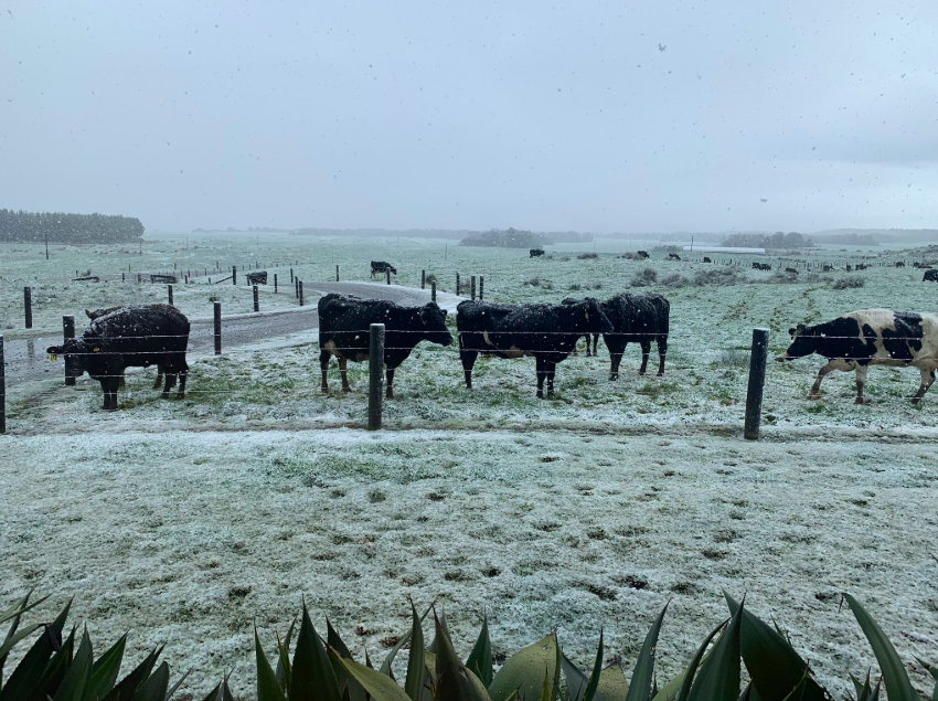
Snow has also fallen near Invercargill, like in Mataura which is around 40 metres above sea level.
Hail showers and heavy squally downpours are affecting the western North Island and will likely increase as we head through Sunday as the colder air advances northwards to cover all of Aotearoa by midnight tonight.
 – Andy Thompson
 – DairyCowQueen – Twitter
More #snomo @TheCountry @TheMusterShow @WeatherWatchNZ @NZMECareers @nzherald @rowie_nz @GrantMcCallum4 @greymouth_nz @GreymouthStar @hokitika_nz pic.twitter.com/QRXhXK3lzt
— Andrew Thompson (@Pandasport) August 4, 2019
Chilly pic.twitter.com/LX8iqbNte7
— Andrew Thompson (@Pandasport) August 4, 2019
#snowing on The West Coast at Sea level #kumara @TheMusterShow @TheCountry @NZMECareers @nzherald @WeatherWatchNZ @GrantMcCallum4 pic.twitter.com/MN7Vcv7af5
— Andrew Thompson (@Pandasport) August 3, 2019
Mataura is 40m above sea level pic.twitter.com/RhjTDWCuZT
— Donald Martin (@DonaldGrassCo) August 3, 2019
– WeatherWatch.co.nz
Comments
Latest Video

Cold weekend, frosts return with high pressure, then a low late next week
The subantarctic airflow spreads over NZ today/tonight and into Saturday, dropping temperatures nationwide. Snow flurries are possible today to lower…
Related Articles
Cold weekend, frosts return with high pressure, then a low late next week
The subantarctic airflow spreads over NZ today/tonight and into Saturday, dropping temperatures nationwide. Snow flurries are possible today to lower…

Wintry burst of weather: Snow, squally showers then sunshine & frosts
A polar change (another one!) arrives on Friday for the South Island and goes nationwide on Saturday, leaving NZ under…

Antarctic southerly for parts of NZ Fri & Sat
For the first time this year a southerly from off Antarctica is heading towards the South Island, followed by more…


Guest on 4/08/2019 12:35pm
All signs of the grand solar minimum. Winter is here…
Guest on 4/08/2019 4:04am
global warming is awesome isn’t it