
> From the WeatherWatch archives
Several large areas of low pressure will affect New Zealand for a full seven days ahead with at least two polar southerlies bringing a huge variety of weather conditions across the country.
Before the colder changes of air there will be surges of warmer, windier, nor’westers.
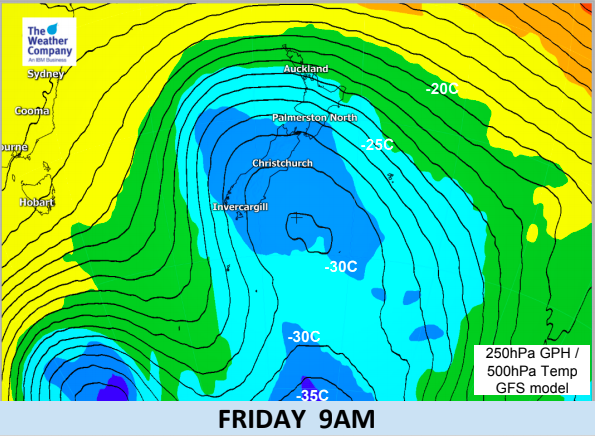
COLDEST AIR:
At this stage the two main cold southerly changes appear to be on Wednesday and again around Friday/The Weekend.
SNOW:
Snow accumulations in the Southern Alp mountain ranges may climb over 1 metre in the next 36 hours with more snow off an on until next Monday potentially doubling or tripling these totals. However this will be high up in the alpine areas. Due to the wind flows and mountains/ranges many eastern areas will be fairly dry with a drier than average week ahead.
RAIN:
Rain will be heavy at times along the West Coast with patchy rain and showers spilling over into other regions and the North Island. However eastern areas of both islands will, for the most part, remain drier than usual. Rainfall totals on the West Coast may be high enough to cause some areas of flooding.
GALES:
Winds will be surging in from the westerly quarter, often swinging between Nor’West and Sou’West. There will be other wind directions in the mix though, including southerlies which are most likely this Wednesday and again this Weekend. As for damage, the good news is most winds appear to be just below damaging threshold but there may be a few surges that cause problems to some trees, power lines and weak old farm sheds. Worth keeping an eye on our wind maps as they precise areas will shift a bit, but generally speaking the worst winds will be through the Southern Alps, the very western side of the Canterbury Plains and around the south of both islands.
WARMTH AND COLD:
The wind flows will cause fluctuation temperatures. Coldest air will be the furthest south you go while the warmest air will be in the east of northern New Zealand. To give you an idea as to how up and down this week will be WeatherWatch.co.nz is forecasting highs in the low 20s for Hawke’s Bay three days this week, but the high one week from now may only be 12 degrees. Further south and Bluff and Gore have single digit highs more than double digit highs this week. If the sun comes out this may go up another degree or so but either way you get the idea – the further south you go the lower the daytime highs will be during this event.


 KEY: 17m/s and above is gale force – so orange red etc.
– WeatherWatch.co.nz
Latest Video

Cold weekend, frosts return with high pressure, then a low late next week
The subantarctic airflow spreads over NZ today/tonight and into Saturday, dropping temperatures nationwide. Snow flurries are possible today to lower…
Related Articles
Cold weekend, frosts return with high pressure, then a low late next week
The subantarctic airflow spreads over NZ today/tonight and into Saturday, dropping temperatures nationwide. Snow flurries are possible today to lower…

Wintry burst of weather: Snow, squally showers then sunshine & frosts
A polar change (another one!) arrives on Friday for the South Island and goes nationwide on Saturday, leaving NZ under…

Antarctic southerly for parts of NZ Fri & Sat
For the first time this year a southerly from off Antarctica is heading towards the South Island, followed by more…

