
> From the WeatherWatch archives
The cold southerly winding its way northwards will hit a deepening low pressure system over the North Island on Saturday – creating for heavy snow in the central North Island and eastern North Island ranges while also bringing gales and heavy rain around various regions of the island.
However at the same time the southerly change will begin to ease over the South Island. Snow showers, possibly to sea level in the morning, will gradually clear across the day with increasing sunny and dry spells.
This clearance means Saturday night in the South Island will be incredibly cold for some. Overnight temperatures will drop below -10 to -15C in calmer conditions through Central Otago and other inland alpine areas.
Meanwhile the North Island will get progressively colder and windier over Saturday with gales around the lower North Island and Cook Strait areas, and out towards Taranaki as the polar air moves northwards and gets sucked into the low.
The polar air hitting heavy rain will mean heavy snow above 500 to 700m in the North Island – and this will fall as heavy rain lower down for the eastern North Island (Hawkes Bay, Gisborne, Wairarapa). The areas are a little drier than usual so this rain, despite being cold, should be welcome by some.
Northerners may wake up to sunny weather on Saturday morning as the centre of the low is usually quite calm – but a bit unstable and as the day goes on the southerlies pick up, cool right down, and bring in downpours – possibly with hail.
Sunday clears up for many parts of the country – but it will be bitterly cold in the South Island and southerlies in the North Island will have single digit feels like temperatures. On Sunday night/Monday morning frosts may become more widespread as winds across New Zealand ease further.
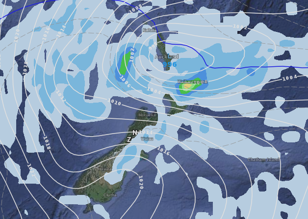
Image / Noon Saturday – a very cold and snowy east to south east flow gradually clears the South Island as it heads north – but a deepening low centred near Auckland and Bay of Plenty will see strong winds, rain and snow circling around the North Island.
– WeatherWatch.co.nz
Comments
Before you add a new comment, take note this story was published on 4 Aug 2016.
Latest Video

NZ VIDEO: Severe weather going into the weekend. Next week: Westerlies continue
Heavy rain and northerly gales are moving across NZ going into the weekend as a large low from the Tasman…
Related Articles
NZ VIDEO: Severe weather going into the weekend. Next week: Westerlies continue
Heavy rain and northerly gales are moving across NZ going into the weekend as a large low from the Tasman…

VIDEO: Low pressure, cold fronts, main feature next two weeks
There are several low pressure zones and cold fronts coming into NZ, with westerly driven weather dominating our weather pattern…

VIDEO: Burst of wind and rain for NZ as low pressure dominates
Air pressure around New Zealand will continue to drop in the days ahead as low pressure systems affect our weather…


Add new comment