
> From the WeatherWatch archives
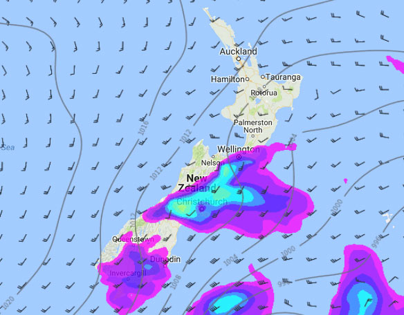
A southwesterly airflow lies over New Zealand today, within this flow a cold change moves northwards pushing up the eastern side of the country during the day.
RainWatch is a series during the weekdays, giving a snapshot about where around New Zealand areas of precipitation may affect your day.
There is the risk of a brief shower or two this morning about the western North Island otherwise it’s looking mainly dry.
Showers move into Wellington and the Wairarapa this afternoon then perhaps into Hawkes Bay later this evening.
Marlborough is mainly dry then mid afternoon as a southerly change pushes in showers develop (more so near the coast), clearing in the evening. Canterbury sees a few early morning showers clear then moving in again late morning / early afternoon as southwesterly winds strengthen, showers may be heavy with a risk of hail / thunder then easing and clearing this evening. Showers may not clear Banks Peninsula till around midday on Thursday however.
Showers, some may be heavy with small hail for Southland and Otago then easing this evening and clearing around midnight.
Parts of coastal Otago may be dry for a time this morning before showers move in around midday.
WeatherWatch.co.nz
Image – Wednesday 4pm, 4th January 2017 rain / MSLP map – weathermap.co.nz
Latest Video

Rain & showers this weekend, colder change next week
Some places will warm up over the next day or so as a nor’wester out of Australia moves across NZ,…
Related Articles
Rain & showers this weekend, colder change next week
Some places will warm up over the next day or so as a nor’wester out of Australia moves across NZ,…

Temperature changes for some regions ahead of heavy West Coast rain
A nor-wester is about to kick in and it’s coming from out of Australia, boosting temperatures in some regions going…

NZ 7 day forecast: Showers, temp changes and heavy West Coast rain
NZ has a fairly messy forecast over the next 7 days, but the main feature will be heavy rain on…

