Rainfall & Soil Moisture Update: Past 7 days + upcoming rainfall (+4 Maps)
5/05/2019 11:04pm

> From the WeatherWatch archives
This week New Zealand is stuck between a large high to our east and a large low out near Australia. This low will likely cross the country this Sunday bringing sub-tropical rain which may be heavy enough to prompt rain warnings in both islands, but before then most places are dry.
Generally speaking this next burst of rain (this weekend) will be more focused on western and northern regions.
Between now and then the South Island’s West Coast will get some showery weather or patchy rain, mostly around Wednesday/Thursday.
Eastern areas of both islands have a drier than average seven days ahead and depending on rainfall totals this Sunday some northern parts of the North Island may also, once again, miss out on soaking rains. But this Sunday isn’t yet locked in – some modelling indicates heavy rain potential in both islands so we’ll keep you posted here at WeatherWatch.co.nz.
HISTORIC RAINFALL: Past 7 days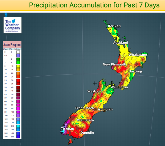
FORECAST RAINFALL: Rainfall expected over the next 3 days (Monday, Tuesday & Wednesday)
UPCOMING RAINFALL COMPARED TO NORMAL: (Red = drier than average, white = normal, blue = wetter than usual)
– Data, as always, thanks to the US Government
SOIL MOISTURE ANOMALY

– Soil map from the National Institute of Water and Atmospheric Research (100% owned by the NZ Government/NZ Taxpayers)
– WeatherWatch.co.nz
Comments
Latest Video

Frosts, clearer skies coming – severe weather possible this weekend
High pressure lies south of NZ today and that placement encourages a colder south-east wind into the North Island bringing…
Related Articles
Frosts, clearer skies coming – severe weather possible this weekend
High pressure lies south of NZ today and that placement encourages a colder south-east wind into the North Island bringing…

NZ: 8 Day outlook as gales & rain ease, high pressure builds
Damaging wind gusts and heavy rain will continue to affect some parts of the North Island and brushing Marlborough today…

Pockets of hit & miss heavy rain, snow moves northwards
Low pressure continues to slowly move across the upper North Island and for some that will bring the sun out,…


Guest on 6/05/2019 12:36am
see theres been no north island rain makers and one map shows you that how Gisborne and NP got rain I don’t know and wellington is more less in the south island
Guest on 6/05/2019 4:24am
Should go and live in Milford Sound then.