Pam pummels East Cape & Gisborne with wild seas & gales, easing late today (+4 Maps)
16/03/2015 12:13am

> From the WeatherWatch archives
UPDATED 1:12pm — Cyclone Pam continues to blast East Cape and Gisborne – with winds likely to be peaking about now, before easing later today.
Pam was this morning downgraded to an ex-tropical cyclone but the winds and rain around it remain severe and cyclone strength … but are substantially weaker than when the storm was Cat 5 on Sunday morning. The word ‘downgraded’ can be a bit misleading as it might imply there is no storm now – however it has simply lost it’s tropical formation and structure, it is still very much a storm.
Roughly 90% of Pam’s severe weather has been out at sea around New Zealand – and that is certainly the case at the moment which is very encouraging.
A lot of people enjoy stormy weather – but we shouldn’t be underestimating just how powerful this low still is and what a relief is has been for northern New Zealand to avoid a direct hit from this deadly and historic tropical storm.
Warnings are given as worst case possible scenarios based on the facts at the time. If a tornado missed hitting a house the warnings would still be justified – same when a severe cyclone narrowly misses our largest city with damaging winds. The 144km/h gust on Great Barrier Island was on the edge of the severe winds – not even in the middle of it!
What is happening for the rest of Monday and into Tuesday?
So, Pam will start to clear New Zealand’s mainland as of late tonight…then out over the Chathams as a rough roaring 40s-like storm.
Southerlies will be theme over the next 24 hours for NZ with showers about – some might be heavy on Tuesday afternoon.
As for today, those in East Cape, Gisborne and Northern Hawkes Bay should hunker down, enjoy the rain, and wait for conditions to ease later today. However the swells are only going to intensify this afternoon with deadly rips and currents. Some coastal erosion is highly likely around Hawkes Bay, Gisborne and East Cape over the next few days.
By Tuesday showers and south west winds will be blowing through – and also easing across the day.
Rain and winds may pick up in other areas as Pam weakens.
When the cyclone was in the tropics all the energy was tightly wrapped around the centre – that centre is now ‘filling in’ and so the isobars are expanding out. This means the peak winds are easing in the middle (why it’s dropped categories over the past 24 hours) – but it also means the winds spread out over a much greater distance. So it will get windier for some places like southern Hawkes Bay, Wairarapa, Wellington – and a few other regions – for a time later today or Tuesday…but not cyclone strength, just the usual ‘kinda windy’ weather we get in NZ frequently.
This will be our final detailed update about Pam, with such a small portion of NZ now in the main risk zone we want to ease back on the frequent serious updates now, to ensure we keep the balance right.
We’ll certanly keep you up to date with the movements of Pam – and how the storm affects East Cape and Gisborne. We’ll also focus on the humanitarian disaster unfolding in Vanuatu now.
Pam is still with us for at least another 12 hours so North Islanders should be up to date with the latest weather warnings and watches from MetService.
– Philip Duncan.
Earlier update: 7am Monday
PAM BRINGS PAIN TO VANUATU BUT SOME JOY TO NEW ZEALAND
Meanwhile Pam isn’t all negative for New Zealand – she has brought rain which farmers and gardeners will be incredibly thankful for. The Ministry for Primary Industries just last week asked WeatherWatch.co.nz to provide extra drought and rain reports for a number of North Island centres. The rain from Pam will be the silving lining many were looking for rainwise and will have a significant reversal on the big dry that has formed in 2015.
Rain today will intensify for some – and there may be issues around the north eastern corner.
Rain is expected to linger longer for some areas in the north today as Pam takes her time to head south past Gisborne.
Rough weather will ease in most places tonight….and by tomorrow conditions will be improving across New Zealand.
We’ll have another update this afternoon.
– By Philip Duncan, head weather analyst
– WeatherWatch.co.nz
IMPORTANT INFORMATION
For many regions this storm will not cause severe weather – but a near miss from a deadly cyclone is not a ‘fizzer’ and forecasts from WeatherWatch.co.nz have singled out eastern Bay of Plenty, East Cape, Gisborne and northern Hawkes Bay as highest risk areas from Pam for the past nine days.
Please ensure you are up to date with all current MetService severe weather outlooks, warnings and watches, even if you are in the South Island – you will find them at MetService.com.
LINKS WE SUGGEST
MetService.com will have the latest weather warnings – we strongly urge you keep up to date with them across Sunday and Monday. In particular look at their Warnings, Watches and Severe Weather Outlook.
Auckland Civil Defence has a free emergency app – click here for instructions on how to download to the particular device you have.
Lert Info – Emergency Texts and Emails – for more info visit www.lert.info and their Facebook page is https://www.facebook.com/lertinfo

RIGHT ON OUR DOORSTEP: Cyclone Pam looms over East Cape in our wind maps this morning. The purple and red shadings highlight the damaging winds around the centre. The storm is very much there – it’s just off the Auckland coastline. From our Maps page / Weathermap.co.nz
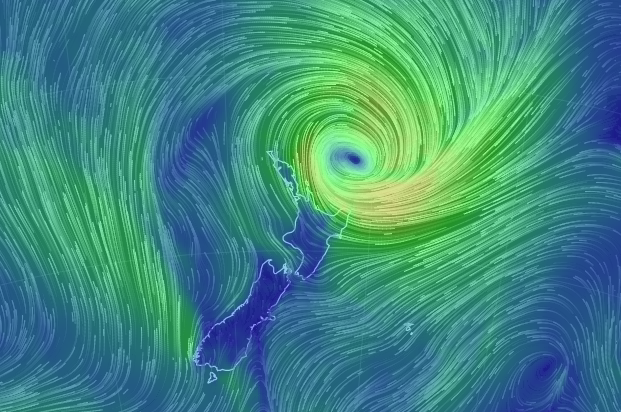
WHERE’S THE STORM? Right here – the latest wind maps show a severe storm looming near East Cape (see our website homepage to view it animated)
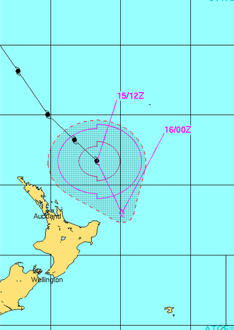
PAM NO LONGER A “TROPICAL CYCLONE” – JTWC (US Govt) issues their Final Map for Cyclone Pam as she loses her tropical centre and starts to morph into more of a Southern Ocean storm as it tracks away to our south east this week.

MTSAT infrared map shows Pam blowing the clouds south, east and west – but clearer skies north of East Cape near the centre. More evidence the low has gone through big structure changes in the past 24 hours.
Comments
Latest Video

Cold weekend, frosts return with high pressure, then a low late next week
The subantarctic airflow spreads over NZ today/tonight and into Saturday, dropping temperatures nationwide. Snow flurries are possible today to lower…
Related Articles
Cold weekend, frosts return with high pressure, then a low late next week
The subantarctic airflow spreads over NZ today/tonight and into Saturday, dropping temperatures nationwide. Snow flurries are possible today to lower…

Wintry burst of weather: Snow, squally showers then sunshine & frosts
A polar change (another one!) arrives on Friday for the South Island and goes nationwide on Saturday, leaving NZ under…

Antarctic southerly for parts of NZ Fri & Sat
For the first time this year a southerly from off Antarctica is heading towards the South Island, followed by more…


Celtickiwi on 16/03/2015 11:42pm
To the WW team,
You guys have been absolute sloggers monitoring Pam and keeping us all up to date. I cannot thank you enough for your hard work and power of educational information that you keep us up to date with.
We live in Hawera, South Taranaki. We had a little blustery weather yesterday but no rain. Today we have lovely rain and it has been resonably steady. It is alot cooler too which is a nice change.
Something I would like to understand is the ‘lull before the storm’. On Sunday everything was still. There was the random little wisp of breeze but mostly it was this eery calm. Even the birds and town were quiet. Why does this happen?
Mike on 16/03/2015 7:59am
From the first day Philip Duncan told viewers about Cyclone Pams path heading towards New Zealands north eastern coast he always said the eye would come close to eastcape but never said once it was going to make a direct hit in that area over land .The path of the eye was always heading in a southeast direction and maybe turning south once it passed the eastcoast of eastcape of the North Island .Cyclone Pam was going to be downgraded to a deep depression once the cyclone hit colder waters as cyclones do around New Zealand. The worst of the weather seem to be down the east coast around Gisborne like W.W said I live in Manurewa and it rained all night not to heavy like W.W said it would and after midnight the wind got up a bit like predicted .If the cyclone came south form Vanuatu, yes Auckland would have been closer to the centre of pam and the weather would have been far worst .I always watch Philip Duncans videos and W.W and you guys/girls are the best weather forcasters around so accurate with the forecasts especially a cyclone that huge and how spot on the forcast was during its decent towards New Zealand. So to all the moaners about it being a fisser it wasn’t it just never got close enough to do its damage and we should all be grateful that we don’t get catagory five cyclones over New Zealand. Just look at the destuction it can do as we have seen on the news in Vanuatu .And those warnings about cyclone Pam I rather be prepared for the worst and hope for the best so thank you Philip Duncan and weather watch for all the effort from you and your team when forcasting storms like Pam.
Mark on 16/03/2015 2:01am
After searching many sites, I settled on your site as being the best most informative, and reliant.
I never knew your site existed until this event and will certainly bookmark your site for future reference above all others. Well done on your brilliant coverage, by far the best weather site in NZ.
Geoff on 16/03/2015 1:50am
Easily the most over-hyped weather event of the past decade for NZ. FIZZER
peter on 16/03/2015 12:18am
For pam to be a good drought breaker it needed to go into the tasman and line up nz and then cross…….it would of weaken a lot in the cold tasman
Derek on 15/03/2015 11:27pm
Well done WW another excellent coverage of this cyclone, I have been watching your site since the cyclone was reported and you really do a fantastic job.
I ignore as I hope you do, all these naysayers about fizzers as they have no idea just how lucky and fortunate they were to have this monster miss us by such a small margin. Cannot believe some people are so brainless in ignoring the information as they are the ones that end up requiring emergency assist.
Here in Whangarei on Sunday the winds were slowly increasing until late afternoon when all suddenly calmed right down. Just could not believe it and was waiting for the ferocity to suddenly hit. Instead of staying up all night I got a good sleep instead and awoke feeling mighty relieved that it missed.
Feel proud WW for a job well done.
hitadmin on 16/03/2015 1:07am
Thanks so much Derek – really appreciate your supportive words. I think we were all a bit surprised how calm it got last night! But it was definitely a possibility as it’s happened a few times before. I’m very sure it has to do with the geography of the upper North Island. When I get some sleep I might write a blog about it!
Cheers – and thanks again
Phil and all the team (all of us worked right through, definitely a team effort!)
peter on 15/03/2015 10:20pm
Well it was for my area but maybe not for your area or other peoples…….its PATCHY
View more comments