NZ’s close brush with a winter cyclone – plus the latest from around NZ (+ MAPS)
25/06/2012 11:35pm

> From the WeatherWatch archives
New Zealand narrowly missed a direct hit by what was essentially a winter cyclone says WeatherWatch.co.nz.
The storm centre only nicked Stewart Island. Head weather analyst Philip Duncan says the rough weather this week comes in two parts. He says the first part was the centre of the storm.. “This is where those hurricane force winds lie, wrapped tightly around the centre as you would normally see in a tropical cyclone”.
He says the second part is the overall storm itself. “While not living up to the wind speeds at the centre, the very strong south west flow which is now pressing across the country brings with it a range of severe weather”.
That weather consists of snow, hail, thunder and squalls.
Mr Duncan says the centre of the storm is already “yesterday’s news” and today’s focus is on the more widespread affect the low will have.
“There is no way this is a fizzer, that implies the storm never eventuated. It did and narrowly missed us which is great news for Southland and Stewart Island residents – it was too close for comfort”.
And now the rough weather has stepped up.
Torrential downpours caused surface flooding around Taranaki this morning along with thunderstorms. The heavy rain also pushed in Palmerston North and Wanganui.
 In the past hour thunderstorms and torrential downpours have been reported around Auckland and Waikato with reports of a hail storm in Hamilton.
The thunder around Auckland mostly tracked to the north of the city centre and to the south but WeatherWatch.co.nz says other heavy showers are on the way in.
(Thunderstorms at 11:30am)
“Aucklanders woke to a calm, mild, morning, but it will be colder, windier and wetter for the next day or two” says Mr Duncan.
Meanwhile the first surge of squalls are moving up the South Island’s West Coast and will move into Taranaki and the North Island’s western coastline this afternoon and evening.
In the South Island snow continues to fall in Queenstown says weather analyst Richard Green. He says snow has been falling off and on in the town since yesterday and may continue for another day.
Meanwhile Dunedin and Christchurch are enjoying sunny weather today thanks to the sheltering affect of the Southern Alps – however Dunedin does still have a moderate risk of snow flurries overnight and on Wednesday as the risk for precipitation lifts – but only lifts to a 40% chance from 20% today.
– WeatherWatch.co.nz
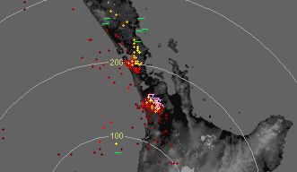
Just how close did the storm get?
The purple/grey areas in the middle are the hurricane force winds
.jpg)
Monday Afternoon (storm centre south west of South Island)
.jpg)
Midnight last night, the block of hurricane force winds lies right on the edge of Stewart Island… if the low had shifted 100kms further north it would’ve been a very different story this morning.

6am Tuesday
.jpg)
6pm this evening – forecast map
Maps provided by our friends at www.Weathermap.co.nz
Story by WeatherWatch.co.nz
Comments
Latest Video

Wintry weather coming: Snow, rain, wind & sunshine
A cold front is moving into NZ from Friday to Sunday with low pressure developing west of NZ and then…
Related Articles
Wintry weather coming: Snow, rain, wind & sunshine
A cold front is moving into NZ from Friday to Sunday with low pressure developing west of NZ and then…

ClimateWatch: JULY outlook & what El Niño means for NZ
El Niño is officially here and still getting stronger in the months ahead, but it’s harder to notice its effects…

Low pressure heading to NZ this weekend & into next week
Many regions have settled weather at the moment with frosts as far north as Auckland this morning, but still some…


Andrew on 26/06/2012 1:11am
A decent shower just passed through Richmond at 1pm and at it’s peak there was sleet on the windscreen. No pitter patter of soft hail at all.
Mark on 26/06/2012 1:01am
Are we going to get that high that is presently sitting to our West?
WW Forecast Team on 26/06/2012 1:30am
Hi Mark – yes we will! Arrives Friday based on current models, which means big frosts for many sheltered areas – potentially nationwide (depends on how much colder it gets over the next 24 hours).
The current forecast for the weekend looks settled 🙂
Cheers
WW